
All about Altmühl-Tal (Dreamliner)
A cycling route starting in Eichstätt, Bavaria, Germany.
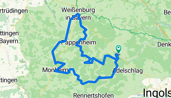
Overview
About this route
Der Klassiker "Eichstätt-Weißenburg" einmal anders auf der verträumten non-diretissima. Dafür mit jeder Menge Abwechslung, Höhenmetern und Aussichten. Die schönsten Flecken dieser Region fast durchgängig auf ruhigen Nebenstraßen oder Radwegen.
Ein Sommertraum! ;)
Auch wenn die Routenführung nicht immer ganz konsequent geradlinig wirkt: jeder Schlenker ist es landschaftlich oder wegen der Verkehrsvermeidung wert! ;)
Sehenswürdigkeiten an der Strecke:
Eichstätt (mit Festung)
Burg Wellheim
Monheim
Keltenschanze (bei Wittesheim)
Möhrenbachtal
Treuchtlingen
Karlsgraben (Fossa Carolina)
Weißenburg
Pappenheim
Solnhofen
Zwölf Apostel (s. Titelbild)
Gailachtal
Dollnstein
- -:--
- Duration
- 130.5 km
- Distance
- 845 m
- Ascent
- 845 m
- Descent
- ---
- Avg. speed
- 582 m
- Avg. speed
Route quality
Waytypes & surfaces along the route
Waytypes
Road
64.4 km
(49 %)
Busy road
29 km
(22 %)
Surfaces
Paved
92.5 km
(71 %)
Unpaved
0.1 km
(<1 %)
Asphalt
90.3 km
(69 %)
Paved (undefined)
1.3 km
(<1 %)
Continue with Bikemap
Use, edit, or download this cycling route
You would like to ride All about Altmühl-Tal (Dreamliner) or customize it for your own trip? Here is what you can do with this Bikemap route:
Free features
- Save this route as favorite or in collections
- Copy & plan your own version of this route
- Split it into stages to create a multi-day tour
- Sync your route with Garmin or Wahoo
Premium features
Free trial for 3 days, or one-time payment. More about Bikemap Premium.
- Navigate this route on iOS & Android
- Export a GPX / KML file of this route
- Create your custom printout (try it for free)
- Download this route for offline navigation
Discover more Premium features.
Get Bikemap PremiumFrom our community
Other popular routes starting in Eichstätt
 Eichstätt - Nürnberg
- Distance
- 79.7 km
- Ascent
- 419 m
- Descent
- 512 m
- Location
- Eichstätt, Bavaria, Germany
 RadTour 6: Geotoptour
- Distance
- 80.7 km
- Ascent
- 556 m
- Descent
- 555 m
- Location
- Eichstätt, Bavaria, Germany
 Dom zu Eichstätt bis Pfünz und zurück über Wellheim
- Distance
- 67.5 km
- Ascent
- 322 m
- Descent
- 323 m
- Location
- Eichstätt, Bavaria, Germany
 Dom zu Eichstätt über Ingolstadt bis Wallheim und zurück
- Distance
- 100.1 km
- Ascent
- 347 m
- Descent
- 347 m
- Location
- Eichstätt, Bavaria, Germany
 Wasserzell-Dollnstein-Aicha und zurück CLONED FROM ROUTE 238504
- Distance
- 32.2 km
- Ascent
- 529 m
- Descent
- 526 m
- Location
- Eichstätt, Bavaria, Germany
 RT 2016, 1. Etappe; Eichstätt - Pappenheim
- Distance
- 32.9 km
- Ascent
- 221 m
- Descent
- 258 m
- Location
- Eichstätt, Bavaria, Germany
 3. Dienstag: Eichstätt-Denkendorf
- Distance
- 34.1 km
- Ascent
- 278 m
- Descent
- 178 m
- Location
- Eichstätt, Bavaria, Germany
 Altmühltal-Donau-Rundfahrt (klein)
- Distance
- 215.9 km
- Ascent
- 1,109 m
- Descent
- 1,107 m
- Location
- Eichstätt, Bavaria, Germany
Open it in the app