

Laaber - Deusmauer
A cycling route starting in Pilsach, Bavaria, Germany.
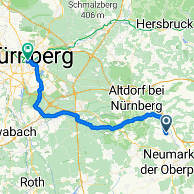
Overview
About this route
Route through Pfeffertshofen, Günching, Deusmauer, Wiesenacker and Dietkirchen; dirt and gravel section between Wiesenacker and Dietkirchen.
- -:--
- Duration
- 22.5 km
- Distance
- 183 m
- Ascent
- 214 m
- Descent
- ---
- Avg. speed
- 582 m
- Max. altitude
Route quality
Waytypes & surfaces along the route
Waytypes
Road
13 km
(58 %)
Track
4.3 km
(19 %)
Surfaces
Paved
19.1 km
(85 %)
Unpaved
2.2 km
(10 %)
Asphalt
17.5 km
(78 %)
Gravel
2.2 km
(10 %)
Route highlights
Points of interest along the route
Photo after 17.5 km
Aussichtspunkt mit Infotafel und Fernrohr.
Photo after 17.5 km
Aussichtspunt mit Infotafel und Fernrohr.
Continue with Bikemap
Use, edit, or download this cycling route
You would like to ride Laaber - Deusmauer or customize it for your own trip? Here is what you can do with this Bikemap route:
Free features
- Save this route as favorite or in collections
- Copy & plan your own version of this route
- Sync your route with Garmin or Wahoo
Premium features
Free trial for 3 days, or one-time payment. More about Bikemap Premium.
- Navigate this route on iOS & Android
- Export a GPX / KML file of this route
- Create your custom printout (try it for free)
- Download this route for offline navigation
Discover more Premium features.
Get Bikemap PremiumFrom our community
Other popular routes starting in Pilsach
 Pilsach-Dillberg
- Distance
- 13.4 km
- Ascent
- 281 m
- Descent
- 136 m
- Location
- Pilsach, Bavaria, Germany
 Busradtour_kanal_20160528_kettenbach-ludwig-main_mdk_dietfurt_ueber_altmühl
- Distance
- 50.6 km
- Ascent
- 59 m
- Descent
- 113 m
- Location
- Pilsach, Bavaria, Germany
 Pilsach-Oberölsbach
- Distance
- 9.9 km
- Ascent
- 81 m
- Descent
- 137 m
- Location
- Pilsach, Bavaria, Germany
 SLA: Entlang der gesamten Schwarzen Laber
- Distance
- 71.7 km
- Ascent
- 165 m
- Descent
- 353 m
- Location
- Pilsach, Bavaria, Germany
 Tour 7 - Kastl
- Distance
- 64.9 km
- Ascent
- 662 m
- Descent
- 662 m
- Location
- Pilsach, Bavaria, Germany
 Laaber - Habsberg
- Distance
- 23.2 km
- Ascent
- 274 m
- Descent
- 279 m
- Location
- Pilsach, Bavaria, Germany
 2. Etappe - Berg/NM-NBG
- Distance
- 41.2 km
- Ascent
- 136 m
- Descent
- 238 m
- Location
- Pilsach, Bavaria, Germany
 Schlossberg Tour
- Distance
- 12 km
- Ascent
- 160 m
- Descent
- 58 m
- Location
- Pilsach, Bavaria, Germany
Open it in the app