

🚴♀️E*Bike🇮🇩+🇨🇭 Glurns-STILFSER-JOCH-Glurns
A cycling route starting in Glurns, Trentino-Alto Adige, Italy.
Overview
About this route
Radtag zum STILFSER-Joch. Am 01.09.2018.
Start und Ziel GLURNS über den Etschtalradweg - Prato allo SELVIO - Ponte Selvio - STIFSER Joch 2758 m - Santa Maria entlang des Münstertales zurück nach GLURNS.
- -:--
- Duration
- 66 km
- Distance
- 1,844 m
- Ascent
- 1,841 m
- Descent
- ---
- Avg. speed
- ---
- Max. altitude

Route photos


Route quality
Waytypes & surfaces along the route
Waytypes
Cycleway
9.2 km
(14 %)
Track
7.9 km
(12 %)
Surfaces
Paved
56.8 km
(86 %)
Unpaved
5.3 km
(8 %)
Asphalt
55.5 km
(84 %)
Gravel
4 km
(6 %)
Route highlights
Points of interest along the route

Photo after 2.9 km
ETSCH Radweg

Photo after 22.6 km

Photo after 26.8 km

Photo after 34.2 km

Photo after 36.3 km
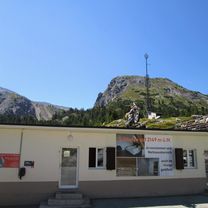
Stilfser-Joch Radtag 2018 am 01.09.18

Photo after 49.7 km
santa-maria

Photo after 65.7 km
glurns start und ziel am radtag 01.09.2018.
Continue with Bikemap
Use, edit, or download this cycling route
You would like to ride 🚴♀️E*Bike🇮🇩+🇨🇭 Glurns-STILFSER-JOCH-Glurns or customize it for your own trip? Here is what you can do with this Bikemap route:
Free features
- Save this route as favorite or in collections
- Copy & plan your own version of this route
- Sync your route with Garmin or Wahoo
Premium features
Free trial for 3 days, or one-time payment. More about Bikemap Premium.
- Navigate this route on iOS & Android
- Export a GPX / KML file of this route
- Create your custom printout (try it for free)
- Download this route for offline navigation
Discover more Premium features.
Get Bikemap PremiumFrom our community
Other popular routes starting in Glurns
 🚴♀️E*Bike🇮🇩 MALS-GLURNS- MERAN
- Distance
- 61 km
- Ascent
- 62 m
- Descent
- 682 m
- Location
- Glurns, Trentino-Alto Adige, Italy
 OrtlerRunde
- Distance
- 314.8 km
- Ascent
- 9,655 m
- Descent
- 9,655 m
- Location
- Glurns, Trentino-Alto Adige, Italy
 Glurns nach Melag (Südtirol)
- Distance
- 28.7 km
- Ascent
- 952 m
- Descent
- 47 m
- Location
- Glurns, Trentino-Alto Adige, Italy
 PASS DAL FUORN/ OFENPASS (por Glurns/ Glorenza)
- Distance
- 28.6 km
- Ascent
- 1,396 m
- Descent
- 156 m
- Location
- Glurns, Trentino-Alto Adige, Italy
 Dol Stilfser Joch
- Distance
- 62 km
- Ascent
- 1,836 m
- Descent
- 1,836 m
- Location
- Glurns, Trentino-Alto Adige, Italy
 Stelvio - Gavia
- Distance
- 96.1 km
- Ascent
- 3,200 m
- Descent
- 2,862 m
- Location
- Glurns, Trentino-Alto Adige, Italy
 🚴♀️E*Bike🇮🇩+🇨🇭 Glurns-STILFSER-JOCH-Glurns
- Distance
- 66 km
- Ascent
- 1,844 m
- Descent
- 1,841 m
- Location
- Glurns, Trentino-Alto Adige, Italy
 GDS - BDS: 05 Glurns - Nauders (15 Schlinigpass, Uina-Schlucht xxxxx)
- Distance
- 56.3 km
- Ascent
- 1,829 m
- Descent
- 1,386 m
- Location
- Glurns, Trentino-Alto Adige, Italy
Open it in the app