

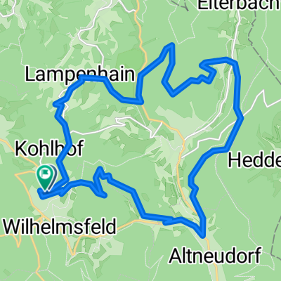
Weißer Stein - Mannheim
A cycling route starting in Wilhelmsfeld, Baden-Wurttemberg, Germany.
Overview
About this route
- -:--
- Duration
- 17.9 km
- Distance
- 89 m
- Ascent
- 546 m
- Descent
- ---
- Avg. speed
- ---
- Max. altitude
Continue with Bikemap
Use, edit, or download this cycling route
You would like to ride Weißer Stein - Mannheim or customize it for your own trip? Here is what you can do with this Bikemap route:
Free features
- Save this route as favorite or in collections
- Copy & plan your own version of this route
- Sync your route with Garmin or Wahoo
Premium features
Free trial for 3 days, or one-time payment. More about Bikemap Premium.
- Navigate this route on iOS & Android
- Export a GPX / KML file of this route
- Create your custom printout (try it for free)
- Download this route for offline navigation
Discover more Premium features.
Get Bikemap PremiumFrom our community
Other popular routes starting in Wilhelmsfeld
 Weißer Stein, Gipfelrunde
- Distance
- 13.5 km
- Ascent
- 377 m
- Descent
- 378 m
- Location
- Wilhelmsfeld, Baden-Wurttemberg, Germany
 Wilhelmsfed-Lampenhain-Heiligkreuz und zurück
- Distance
- 21.2 km
- Ascent
- 629 m
- Descent
- 632 m
- Location
- Wilhelmsfeld, Baden-Wurttemberg, Germany
 Teltschickturm - handschuh - heidelberg
- Distance
- 11.3 km
- Ascent
- 65 m
- Descent
- 480 m
- Location
- Wilhelmsfeld, Baden-Wurttemberg, Germany
 römerman
- Distance
- 34.2 km
- Ascent
- 626 m
- Descent
- 626 m
- Location
- Wilhelmsfeld, Baden-Wurttemberg, Germany
 Heidelberg Ostermontag
- Distance
- 39.5 km
- Ascent
- 1,189 m
- Descent
- 1,205 m
- Location
- Wilhelmsfeld, Baden-Wurttemberg, Germany
 Vom Weissen Stein nach Handschuhsheim rollen lassen
- Distance
- 17 km
- Ascent
- 209 m
- Descent
- 618 m
- Location
- Wilhelmsfeld, Baden-Wurttemberg, Germany
 Bianx & Sam Extension
- Distance
- 21 km
- Ascent
- 429 m
- Descent
- 498 m
- Location
- Wilhelmsfeld, Baden-Wurttemberg, Germany
 Vom Weissen Stein nach Handschuhsheim durch den Wald, danach durchs Neuenheimer Feld nach Wieblingen
- Distance
- 12.1 km
- Ascent
- 48 m
- Descent
- 494 m
- Location
- Wilhelmsfeld, Baden-Wurttemberg, Germany
Open it in the app