

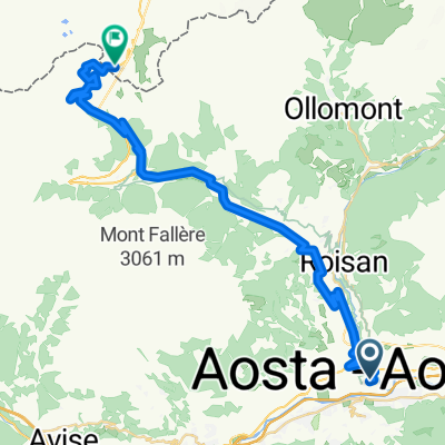
F52 aosta to nus
A cycling route starting in Aosta, Aosta Valley, Italy.
Overview
About this route
8.8 miles 54 minutes easy some walking
- -:--
- Duration
- 14.3 km
- Distance
- 48 m
- Ascent
- 85 m
- Descent
- ---
- Avg. speed
- ---
- Max. altitude
Route quality
Waytypes & surfaces along the route
Waytypes
Cycleway
6.3 km
(44 %)
Road
3.4 km
(24 %)
Surfaces
Paved
9.3 km
(65 %)
Unpaved
1 km
(7 %)
Asphalt
9.2 km
(64 %)
Gravel
1 km
(7 %)
Continue with Bikemap
Use, edit, or download this cycling route
You would like to ride F52 aosta to nus or customize it for your own trip? Here is what you can do with this Bikemap route:
Free features
- Save this route as favorite or in collections
- Copy & plan your own version of this route
- Sync your route with Garmin or Wahoo
Premium features
Free trial for 3 days, or one-time payment. More about Bikemap Premium.
- Navigate this route on iOS & Android
- Export a GPX / KML file of this route
- Create your custom printout (try it for free)
- Download this route for offline navigation
Discover more Premium features.
Get Bikemap PremiumFrom our community
Other popular routes starting in Aosta
 Francja: nie Pinerolo, a Aosta - reverse
- Distance
- 618.6 km
- Ascent
- 7,251 m
- Descent
- 7,252 m
- Location
- Aosta, Aosta Valley, Italy
 Aosta - Aosta Day 1
- Distance
- 140.8 km
- Ascent
- 3,178 m
- Descent
- 3,187 m
- Location
- Aosta, Aosta Valley, Italy
 Alpencross 2007/2 - Aosta bis GranParadiso
- Distance
- 43.2 km
- Ascent
- 2,071 m
- Descent
- 48 m
- Location
- Aosta, Aosta Valley, Italy
 Col du Gd-St Bernard
- Distance
- 36.9 km
- Ascent
- 1,917 m
- Descent
- 23 m
- Location
- Aosta, Aosta Valley, Italy
 Francja: nie Pinerolo, a Aosta - reverse (BONUSY)
- Distance
- 691.8 km
- Ascent
- 9,757 m
- Descent
- 8,365 m
- Location
- Aosta, Aosta Valley, Italy
 F52 aosta to nus
- Distance
- 14.3 km
- Ascent
- 48 m
- Descent
- 85 m
- Location
- Aosta, Aosta Valley, Italy
 2-Tag_Aosta-ValD-isere
- Distance
- 94.3 km
- Ascent
- 2,400 m
- Descent
- 1,177 m
- Location
- Aosta, Aosta Valley, Italy
 Alps 1991 18.8. Tag4b
- Distance
- 79.5 km
- Ascent
- 1,881 m
- Descent
- 1,973 m
- Location
- Aosta, Aosta Valley, Italy
Open it in the app