

Neukirchen-Neuhaus-Hohenstadt-Neukirchen
A cycling route starting in Etzelwang, Bavaria, Germany.
Overview
About this route
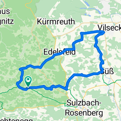
Start in Neukirchen (Sul.Ro.) - auf dem Grottenradweg bis Neuhaus a.d. Pegnitz - den Pegnitztalradweg bis Hohenstadt und dem Fünf-Flüsse-Radweg zurück nach Neukirchen
- -:--
- Duration
- 59.9 km
- Distance
- 462 m
- Ascent
- 485 m
- Descent
- ---
- Avg. speed
- ---
- Max. altitude
Route quality
Waytypes & surfaces along the route
Waytypes
Track
20.1 km
(34 %)
Quiet road
13.6 km
(23 %)
Surfaces
Paved
33.2 km
(55 %)
Unpaved
21.4 km
(36 %)
Asphalt
32.6 km
(54 %)
Gravel
20.4 km
(34 %)
Continue with Bikemap
Use, edit, or download this cycling route
You would like to ride Neukirchen-Neuhaus-Hohenstadt-Neukirchen or customize it for your own trip? Here is what you can do with this Bikemap route:
Free features
- Save this route as favorite or in collections
- Copy & plan your own version of this route
- Sync your route with Garmin or Wahoo
Premium features
Free trial for 3 days, or one-time payment. More about Bikemap Premium.
- Navigate this route on iOS & Android
- Export a GPX / KML file of this route
- Create your custom printout (try it for free)
- Download this route for offline navigation
Discover more Premium features.
Get Bikemap PremiumFrom our community
Other popular routes starting in Etzelwang
 Hubmersberg - Etzelwang - Hartenstein - Korbmachersteig
- Distance
- 41.1 km
- Ascent
- 619 m
- Descent
- 615 m
- Location
- Etzelwang, Bavaria, Germany
 Tour 12 (Landkreis Amberg-Sulzbach)
- Distance
- 45.3 km
- Ascent
- 496 m
- Descent
- 488 m
- Location
- Etzelwang, Bavaria, Germany
 Simultankirchen-Radweg Route 2 / Neunkirchen bei Sulzbach Rosenberg
- Distance
- 23 km
- Ascent
- 296 m
- Descent
- 299 m
- Location
- Etzelwang, Bavaria, Germany
 Hauptwasserscheide - Osterhöhle - Peilstein
- Distance
- 12.7 km
- Ascent
- 211 m
- Descent
- 209 m
- Location
- Etzelwang, Bavaria, Germany
 Lehenbachtal - Sebald - Lichtenegg
- Distance
- 28.7 km
- Ascent
- 514 m
- Descent
- 475 m
- Location
- Etzelwang, Bavaria, Germany
 Neukirchen-Neuhaus-Hohenstadt-Neukirchen
- Distance
- 59.9 km
- Ascent
- 462 m
- Descent
- 485 m
- Location
- Etzelwang, Bavaria, Germany
 Fünf-Flüsse-Radweg_3.Etappe CLONED FROM ROUTE 440421
- Distance
- 68 km
- Ascent
- 260 m
- Descent
- 320 m
- Location
- Etzelwang, Bavaria, Germany
 Route 3 - Radrundweg
- Distance
- 20.7 km
- Ascent
- 316 m
- Descent
- 316 m
- Location
- Etzelwang, Bavaria, Germany
Open it in the app