

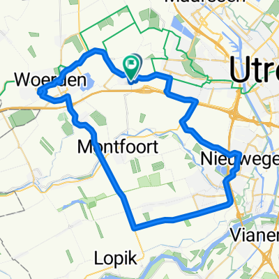
Rondje Montfoort-Hogebrug 50km
A cycling route starting in Montfoort, Utrecht, The Netherlands.
Overview
About this route
Montfoort naar Benschop, dan Polsbroekerdam en via Cabauw naar Schoonhoven. Verder naar Vlist en via Haastrecht naar Hogebrug. Dan richting Woerden en via Linschoten terug naar Montfoort. Vlakke rit.
- -:--
- Duration
- 49.4 km
- Distance
- 0 m
- Ascent
- 0 m
- Descent
- ---
- Avg. speed
- ---
- Max. altitude
Route quality
Waytypes & surfaces along the route
Waytypes
Quiet road
23.9 km
(48 %)
Cycleway
12.7 km
(26 %)
Surfaces
Paved
22.6 km
(46 %)
Asphalt
22.1 km
(45 %)
Paving stones
0.6 km
(1 %)
Undefined
26.8 km
(54 %)
Continue with Bikemap
Use, edit, or download this cycling route
You would like to ride Rondje Montfoort-Hogebrug 50km or customize it for your own trip? Here is what you can do with this Bikemap route:
Free features
- Save this route as favorite or in collections
- Copy & plan your own version of this route
- Sync your route with Garmin or Wahoo
Premium features
Free trial for 3 days, or one-time payment. More about Bikemap Premium.
- Navigate this route on iOS & Android
- Export a GPX / KML file of this route
- Create your custom printout (try it for free)
- Download this route for offline navigation
Discover more Premium features.
Get Bikemap PremiumFrom our community
Other popular routes starting in Montfoort
 Ronde Montfoort-Mijdrecht 55km
- Distance
- 55.2 km
- Ascent
- 0 m
- Descent
- 0 m
- Location
- Montfoort, Utrecht, The Netherlands
 Route in Harmelen
- Distance
- 85.2 km
- Ascent
- 146 m
- Descent
- 147 m
- Location
- Montfoort, Utrecht, The Netherlands
 testrondje
- Distance
- 47.5 km
- Ascent
- 0 m
- Descent
- 0 m
- Location
- Montfoort, Utrecht, The Netherlands
 2017 07 06 Willeskop route
- Distance
- 51.2 km
- Ascent
- 0 m
- Descent
- 0 m
- Location
- Montfoort, Utrecht, The Netherlands
 Montfoort Nederijnseplas Harmelen 48km
- Distance
- 48 km
- Ascent
- 0 m
- Descent
- 0 m
- Location
- Montfoort, Utrecht, The Netherlands
 Route in Harmelen
- Distance
- 119.6 km
- Ascent
- 215 m
- Descent
- 213 m
- Location
- Montfoort, Utrecht, The Netherlands
 Route in Harmelen
- Distance
- 118.4 km
- Ascent
- 213 m
- Descent
- 213 m
- Location
- Montfoort, Utrecht, The Netherlands
 Amelisweerd
- Distance
- 34.6 km
- Ascent
- 5 m
- Descent
- 4 m
- Location
- Montfoort, Utrecht, The Netherlands
Open it in the app