

Gitschital Bike
A cycling route starting in Seedorf, Canton of Uri, Switzerland.
Overview
About this route
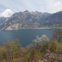
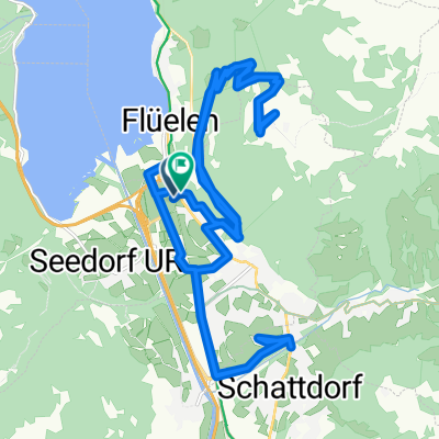
Gitschital Bike offers you a fantastic combination between Lake Lucerne and a mountain valley. This varied tour, peppered with hearty climbs, takes you into a quiet and secluded side valley. From Altdorf train station, you ride north to Wild Ried and then west along a country path to Unterdorf. Besides visiting the A Pro Castle and its mineral exhibition, an additional loop to Lake Uri with its bathing islands called Lorelei is recommended. After the turnoff at the St. Lazarus Monastery, whose origins date back to the Middle Ages and which is the oldest monastery in the canton of Uri, the tour continuously climbs up to the Gitschital forest road. This winding road with sharp climbs is challenging. Before entering the tunnel into Gitschital, you should definitely stop at the Stotzigen viewpoint – the view of the Reuss delta is overwhelming. The last 3 kilometers lead through cool forest sections and alpine meadows before you reach the Gitschitaler Boden, the highest point of the route. You take the same way down to Bodenwald. Then you roll south through the Freiherrendorf, with views of the historic castle ruins of Attinghausen, back to the starting point.
- -:--
- Duration
- 17.5 km
- Distance
- 914 m
- Ascent
- 126 m
- Descent
- ---
- Avg. speed
- ---
- Max. altitude

Route quality
Waytypes & surfaces along the route
Waytypes
Track
8.8 km
(50 %)
Quiet road
3.3 km
(19 %)
Surfaces
Paved
11.9 km
(68 %)
Unpaved
3 km
(17 %)
Paved (undefined)
6 km
(34 %)
Asphalt
5.6 km
(32 %)
Continue with Bikemap
Use, edit, or download this cycling route
You would like to ride Gitschital Bike or customize it for your own trip? Here is what you can do with this Bikemap route:
Free features
- Save this route as favorite or in collections
- Copy & plan your own version of this route
- Sync your route with Garmin or Wahoo
Premium features
Free trial for 3 days, or one-time payment. More about Bikemap Premium.
- Navigate this route on iOS & Android
- Export a GPX / KML file of this route
- Create your custom printout (try it for free)
- Download this route for offline navigation
Discover more Premium features.
Get Bikemap PremiumFrom our community
Other popular routes starting in Seedorf
 Day 9 Tour de Toblerone
- Distance
- 144.9 km
- Ascent
- 1,616 m
- Descent
- 1,378 m
- Location
- Seedorf, Canton of Uri, Switzerland
 Gitschital Bike
- Distance
- 17.5 km
- Ascent
- 914 m
- Descent
- 126 m
- Location
- Seedorf, Canton of Uri, Switzerland
 Entspannende Route in Seedorf
- Distance
- 4.1 km
- Ascent
- 230 m
- Descent
- 9 m
- Location
- Seedorf, Canton of Uri, Switzerland
 Reussdamm Seedorf Erstfeld Seedorf
- Distance
- 13.2 km
- Ascent
- 186 m
- Descent
- 182 m
- Location
- Seedorf, Canton of Uri, Switzerland
 Seedorf See Bodenwald
- Distance
- 6.2 km
- Ascent
- 77 m
- Descent
- 76 m
- Location
- Seedorf, Canton of Uri, Switzerland
 2 107, Altdorf nach Flüelen, Eggberge Talstation, Altdorf
- Distance
- 29.5 km
- Ascent
- 1,703 m
- Descent
- 1,696 m
- Location
- Seedorf, Canton of Uri, Switzerland
 Klausenpass
- Distance
- 53.6 km
- Ascent
- 1,682 m
- Descent
- 1,679 m
- Location
- Seedorf, Canton of Uri, Switzerland
 Altdorf, Glarus, Siebnen, Einsiedeln, Schwyz
- Distance
- 134.8 km
- Ascent
- 2,672 m
- Descent
- 2,653 m
- Location
- Seedorf, Canton of Uri, Switzerland
Open it in the app