
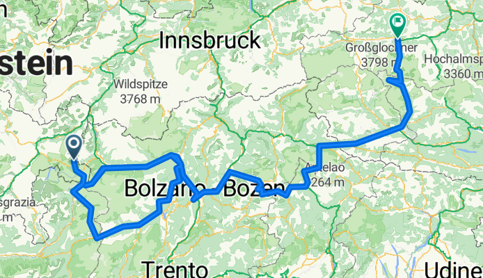
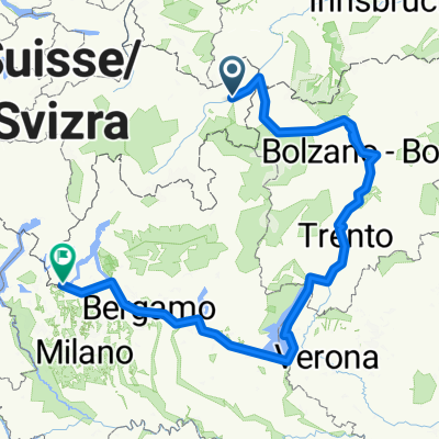
Scuol-Oberplars-Cortina d'Ampezzo-Lienz-Bruck
A cycling route starting in Scuol, Grisons, Switzerland.
Overview
About this route
1.etapa:Scuol-Pass da Constainas(2251m)-Umbrail Pass(2501m)-Santa Caterina
2.etapa:Santa C.-Passo di Gavia(2652m)-Ponte di Legno-Passo del Tonale(1883m)-Oberplars
3.etapa:Oberplars-Stelvio(2758m)-Oberplars /140km , +2341m/
4.etapa:Oberplars-Bolzano-Passo Sella(2244m)- Monti Pallidi
5.etapa:Monti P.-Passo Pordoi(2239m)-Cortina d'Ampezzo-Passo Falzarego(2105m)-Toblach-Lienz
6.etapa:Grossglockner strasse /Lienz-Bruck/ Kaiser Franz Josef Hohe(2369m)-Hochtor(2504m)
- -:--
- Duration
- 690.7 km
- Distance
- 10,034 m
- Ascent
- 11,470 m
- Descent
- ---
- Avg. speed
- ---
- Max. altitude
Route highlights
Points of interest along the route
Point of interest after 0.9 km
Pass da Constainas - 2251m n.m.

Point of interest after 24.7 km
Umbrail Pass - 2501m n.m

Point of interest after 66.9 km
Passo di Gavia - 2652m n.m.
Point of interest after 92.4 km
Passo del Tonale - 1883m n.m.
Point of interest after 274.7 km
Passo dello Stelvio - 2758m n.m.
Point of interest after 451.1 km
Passo Sella - 2244m n.m.
Point of interest after 462.8 km
Passo Pordoi - 2239m n.
Point of interest after 493.6 km
Passo Falzarego - 2105m n.m.
Point of interest after 645.8 km
Kaiser-Franz-Josef-Hohe (2369m n.m.)
Point of interest after 660.6 km
Hochtor - 2504m n.m.
Continue with Bikemap
Use, edit, or download this cycling route
You would like to ride Scuol-Oberplars-Cortina d'Ampezzo-Lienz-Bruck or customize it for your own trip? Here is what you can do with this Bikemap route:
Free features
- Save this route as favorite or in collections
- Copy & plan your own version of this route
- Split it into stages to create a multi-day tour
- Sync your route with Garmin or Wahoo
Premium features
Free trial for 3 days, or one-time payment. More about Bikemap Premium.
- Navigate this route on iOS & Android
- Export a GPX / KML file of this route
- Create your custom printout (try it for free)
- Download this route for offline navigation
Discover more Premium features.
Get Bikemap PremiumFrom our community
Other popular routes starting in Scuol
 Von Schuls bis Pontresina
- Distance
- 101.3 km
- Ascent
- 3,819 m
- Descent
- 3,213 m
- Location
- Scuol, Grisons, Switzerland
 Bike-Tour 2025 Etappe1
- Distance
- 60.7 km
- Ascent
- 2,160 m
- Descent
- 1,396 m
- Location
- Scuol, Grisons, Switzerland
 12.9.22 Scoul - Martina
- Distance
- 22.3 km
- Ascent
- 398 m
- Descent
- 649 m
- Location
- Scuol, Grisons, Switzerland
 Bike Tour 2025
- Distance
- 198.1 km
- Ascent
- 6,810 m
- Descent
- 6,796 m
- Location
- Scuol, Grisons, Switzerland
 Inn - Etappe 1 scuol - Tschupbach
- Distance
- 39.7 km
- Ascent
- 1,056 m
- Descent
- 1,325 m
- Location
- Scuol, Grisons, Switzerland
 Übersgebirgradln 2: Heidelberger Hütte - Sesvenna Hütte - St. Maria
- Distance
- 60.4 km
- Ascent
- 1,998 m
- Descent
- 2,885 m
- Location
- Scuol, Grisons, Switzerland
 Nationalpark Bike-Marathon - Start in S'charl
- Distance
- 132.9 km
- Ascent
- 3,165 m
- Descent
- 3,165 m
- Location
- Scuol, Grisons, Switzerland
 Reschen nach Chiasso original
- Distance
- 582.2 km
- Ascent
- 5,425 m
- Descent
- 6,464 m
- Location
- Scuol, Grisons, Switzerland
Open it in the app