parquÃmetros
A cycling route starting in San Vicente, Región del Libertador General Bernardo O’Higgins, Chile.
Overview
About this route
- -:--
- Duration
- 14.1 km
- Distance
- 20 m
- Ascent
- 22 m
- Descent
- ---
- Avg. speed
- ---
- Max. altitude
Route quality
Waytypes & surfaces along the route
Waytypes
Road
5.9 km
(42 %)
Busy road
5.1 km
(36 %)
Surfaces
Paved
11.2 km
(79 %)
Unpaved
0.1 km
(<1 %)
Asphalt
5.8 km
(41 %)
Paved (undefined)
5.3 km
(38 %)
Continue with Bikemap
Use, edit, or download this cycling route
You would like to ride parquÃmetros or customize it for your own trip? Here is what you can do with this Bikemap route:
Free features
- Save this route as favorite or in collections
- Copy & plan your own version of this route
- Sync your route with Garmin or Wahoo
Premium features
Free trial for 3 days, or one-time payment. More about Bikemap Premium.
- Navigate this route on iOS & Android
- Export a GPX / KML file of this route
- Create your custom printout (try it for free)
- Download this route for offline navigation
Discover more Premium features.
Get Bikemap PremiumFrom our community
Other popular routes starting in San Vicente
- De H-50, Quinta de Tilcoco a H-574, Quinta de Tilcoco
- Distance
- 106.8 km
- Ascent
- 449 m
- Descent
- 454 m
- Location
- San Vicente, Región del Libertador General Bernardo O’Higgins, Chile
- San Vicente - San José de Marchihue - Los Maitenes - Cruce Ruta 90 (Marchihue), San Vicente to Michimalongo 195–315, San Vicente
- Distance
- 12.9 km
- Ascent
- 40 m
- Descent
- 12 m
- Location
- San Vicente, Región del Libertador General Bernardo O’Higgins, Chile
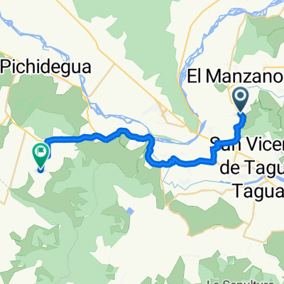
- sn vicente hasta laguna sn vicente..
- Distance
- 24 km
- Ascent
- 92 m
- Descent
- 92 m
- Location
- San Vicente, Región del Libertador General Bernardo O’Higgins, Chile
- De Peumo a Avenida España 1536, San Vicente de Taguatagua
- Distance
- 13.7 km
- Ascent
- 117 m
- Descent
- 87 m
- Location
- San Vicente, Región del Libertador General Bernardo O’Higgins, Chile
- De Calle A. Gines Yáñez 104, San Vicente de Taguatagua a Aguas Claras 318, Peumo
- Distance
- 13.6 km
- Ascent
- 109 m
- Descent
- 141 m
- Location
- San Vicente, Región del Libertador General Bernardo O’Higgins, Chile
- parquÃmetros
- Distance
- 14.1 km
- Ascent
- 20 m
- Descent
- 22 m
- Location
- San Vicente, Región del Libertador General Bernardo O’Higgins, Chile
- De H-574 760, Quinta de Tilcoco a H-574 760, Quinta de Tilcoco
- Distance
- 22.9 km
- Ascent
- 265 m
- Descent
- 277 m
- Location
- San Vicente, Región del Libertador General Bernardo O’Higgins, Chile
- Ruta H-774, Peumo a Walker MartÃnez, Peumo
- Distance
- 6.4 km
- Ascent
- 23 m
- Descent
- 6 m
- Location
- San Vicente, Región del Libertador General Bernardo O’Higgins, Chile
Open it in the app