

Vom Weissen Stein nach Handschuhsheim durch den Wald
A cycling route starting in Wilhelmsfeld, Baden-Wurttemberg, Germany.
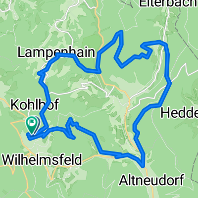
Overview
About this route
Auf kurzem Wege durch den Wald vom Weissen Stein nach Handschuhsheim. Schöner Ausblickspunkt auf das Mühlbachtal auf halber Höhe. Es geht fast nur "geradeaus", nur den Abzweig nach Rechts (statt steil geradeaus auf den Heiligenberg) muss man erwischen. (Ich hoffe, dass ich's auf der Karte richtig getroffen habe.)
- -:--
- Duration
- 5.3 km
- Distance
- 33 m
- Ascent
- 462 m
- Descent
- ---
- Avg. speed
- ---
- Max. altitude
Continue with Bikemap
Use, edit, or download this cycling route
You would like to ride Vom Weissen Stein nach Handschuhsheim durch den Wald or customize it for your own trip? Here is what you can do with this Bikemap route:
Free features
- Save this route as favorite or in collections
- Copy & plan your own version of this route
- Sync your route with Garmin or Wahoo
Premium features
Free trial for 3 days, or one-time payment. More about Bikemap Premium.
- Navigate this route on iOS & Android
- Export a GPX / KML file of this route
- Create your custom printout (try it for free)
- Download this route for offline navigation
Discover more Premium features.
Get Bikemap PremiumFrom our community
Other popular routes starting in Wilhelmsfeld
 Von Weinheim bis Heiligkreuzsteinach
- Distance
- 8.7 km
- Ascent
- 306 m
- Descent
- 339 m
- Location
- Wilhelmsfeld, Baden-Wurttemberg, Germany
 römerman
- Distance
- 34.2 km
- Ascent
- 626 m
- Descent
- 626 m
- Location
- Wilhelmsfeld, Baden-Wurttemberg, Germany
 Vom Weissen Stein nach Handschuhsheim durch den Wald, danach durchs Neuenheimer Feld nach Wieblingen
- Distance
- 12.1 km
- Ascent
- 48 m
- Descent
- 494 m
- Location
- Wilhelmsfeld, Baden-Wurttemberg, Germany
 Teltschickturm - handschuh - heidelberg
- Distance
- 11.3 km
- Ascent
- 65 m
- Descent
- 480 m
- Location
- Wilhelmsfeld, Baden-Wurttemberg, Germany
 Heidelberg Ostermontag
- Distance
- 39.5 km
- Ascent
- 1,189 m
- Descent
- 1,205 m
- Location
- Wilhelmsfeld, Baden-Wurttemberg, Germany
 Vom Weissen Stein nach Handschuhsheim rollen lassen
- Distance
- 17 km
- Ascent
- 209 m
- Descent
- 618 m
- Location
- Wilhelmsfeld, Baden-Wurttemberg, Germany
 Ziegelhausen, Heiligkreuzsteinach, Hirschhorn, Schönbrunn
- Distance
- 55.1 km
- Ascent
- 1,407 m
- Descent
- 1,408 m
- Location
- Wilhelmsfeld, Baden-Wurttemberg, Germany
 Wilhelmsfed-Lampenhain-Heiligkreuz und zurück
- Distance
- 21.2 km
- Ascent
- 629 m
- Descent
- 632 m
- Location
- Wilhelmsfeld, Baden-Wurttemberg, Germany
Open it in the app