

SRT LC to Furman
A cycling route starting in Mauldin, South Carolina, United States.
Overview
About this route
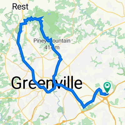
Swamp Rabbit Trail starting at Lake Conestee to Furman trail entrance
- -:--
- Duration
- 51.6 km
- Distance
- 220 m
- Ascent
- 218 m
- Descent
- ---
- Avg. speed
- ---
- Max. altitude

Route quality
Waytypes & surfaces along the route
Waytypes
Path
31 km
(60 %)
Cycleway
10.3 km
(20 %)
Surfaces
Paved
47.5 km
(92 %)
Unpaved
1.5 km
(3 %)
Asphalt
44.9 km
(87 %)
Concrete
1.5 km
(3 %)
Continue with Bikemap
Use, edit, or download this cycling route
You would like to ride SRT LC to Furman or customize it for your own trip? Here is what you can do with this Bikemap route:
Free features
- Save this route as favorite or in collections
- Copy & plan your own version of this route
- Sync your route with Garmin or Wahoo
Premium features
Free trial for 3 days, or one-time payment. More about Bikemap Premium.
- Navigate this route on iOS & Android
- Export a GPX / KML file of this route
- Create your custom printout (try it for free)
- Download this route for offline navigation
Discover more Premium features.
Get Bikemap PremiumFrom our community
Other popular routes starting in Mauldin
 Battery Test Ride, Mauldin
- Distance
- 21 km
- Ascent
- 174 m
- Descent
- 173 m
- Location
- Mauldin, South Carolina, United States
 201 Ponders Ray Ln, Greenville to 201 Ponders Ray Ln, Greenville
- Distance
- 56.5 km
- Ascent
- 766 m
- Descent
- 788 m
- Location
- Mauldin, South Carolina, United States
 Innovation Drive 75, Greenville to Innovation Drive 25, Greenville
- Distance
- 15.2 km
- Ascent
- 94 m
- Descent
- 92 m
- Location
- Mauldin, South Carolina, United States
 201 Ponders Ray Ln, Greenville to 201 Ponders Ray Ln, Greenville
- Distance
- 60.7 km
- Ascent
- 455 m
- Descent
- 457 m
- Location
- Mauldin, South Carolina, United States
 US Pro TT
- Distance
- 11.8 km
- Ascent
- 130 m
- Descent
- 131 m
- Location
- Mauldin, South Carolina, United States
 505 Huntington Rd, Greenville to 201 Ponders Ray Ln, Greenville
- Distance
- 56.1 km
- Ascent
- 737 m
- Descent
- 740 m
- Location
- Mauldin, South Carolina, United States
 SRT LC to Furman
- Distance
- 51.6 km
- Ascent
- 220 m
- Descent
- 218 m
- Location
- Mauldin, South Carolina, United States
 42–46 Spanco Dr, Greenville to 42–46 Spanco Dr, Greenville
- Distance
- 5.7 km
- Ascent
- 37 m
- Descent
- 38 m
- Location
- Mauldin, South Carolina, United States
Open it in the app