

Vulcanul stins, Şumigu
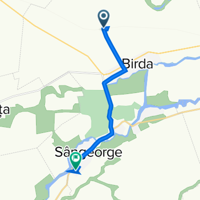
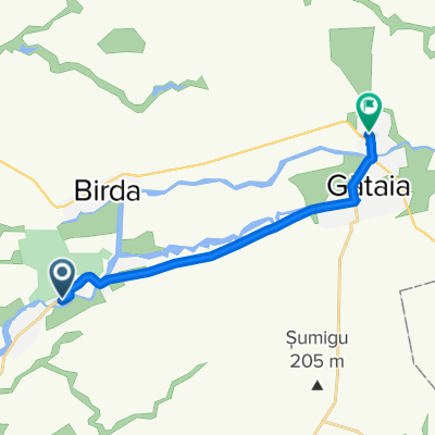
A cycling route starting in Birda, Timiș County, Romania.
Overview
About this route
Regotrans:
Timisoara-Resita: 7:35-8:26
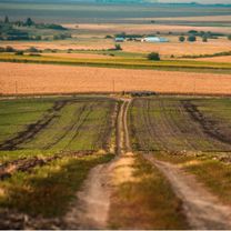
Banatul de câmpie, a peaceful place with fields that have the best soil in the country, chernozem, appears undisturbed in its eternity, but in its depths swirl marshes and volcanoes that once shaped the current structure of the earth's crust through their activities. About all this, like any beautiful story, there are legends. Such a place is the Șumig Hill at Semlacu Mare (near the town of Gătaia), which had its period of glory and now appears as a mound of earth raised and green in spring, but towards which the elderly locals look with fear, because it is never known when the "giant" may awaken.
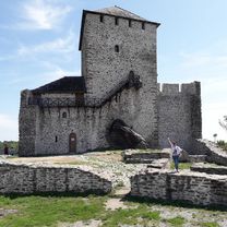
In the 13th century, to defend Banat against Tatar invasions, King Bela IV of Hungary erected several fortresses, including the Somlyo-Selacu Mare fortress, which was of particular strategic importance "as it was built on Șumig Hill (205 meters altitude) and thus dominated the surrounding territory up to Vârşeţ", say medieval historians.
One of the most beautiful legends about Șumig Hill tells of the "iron grass" that supposedly grows here, but is only visible on the night of Saint John's Day.
=================================
TO REMEMBER:
ROAD SEGMENTS:
Rovinita Mare - Percosova = macadam
Şoşdea - Tormac = macadam + ballast + dirt (I struggled to pass with the trekking bike, as the mud was dry).
The rest of the road is asphalted.
- -:--
- Duration
- 88.4 km
- Distance
- 172 m
- Ascent
- 197 m
- Descent
- ---
- Avg. speed
- ---
- Max. altitude

Route photos


Route quality
Waytypes & surfaces along the route
Waytypes
Road
23 km
(26 %)
Quiet road
10.6 km
(12 %)
Surfaces
Paved
76 km
(86 %)
Unpaved
4.4 km
(5 %)
Asphalt
76 km
(86 %)
Gravel
1.8 km
(2 %)
Route highlights
Points of interest along the route
Photo after 26.4 km
Dealul Sumigu
Point of interest after 45.9 km
Magazin alimentar
Point of interest after 53.2 km
Terasa
Point of interest after 69.6 km
Terasa
Point of interest after 81.8 km
Terasa
Continue with Bikemap
Use, edit, or download this cycling route
You would like to ride Vulcanul stins, Şumigu or customize it for your own trip? Here is what you can do with this Bikemap route:
Free features
- Save this route as favorite or in collections
- Copy & plan your own version of this route
- Split it into stages to create a multi-day tour
- Sync your route with Garmin or Wahoo
Premium features
Free trial for 3 days, or one-time payment. More about Bikemap Premium.
- Navigate this route on iOS & Android
- Export a GPX / KML file of this route
- Create your custom printout (try it for free)
- Download this route for offline navigation
Discover more Premium features.
Get Bikemap PremiumFrom our community
Other popular routes starting in Birda
 Biserica ortodoxa din Optaiţa
- Distance
- 101.5 km
- Ascent
- 267 m
- Descent
- 296 m
- Location
- Birda, Timiș County, Romania
 Vulcanul stins, Şumigu
- Distance
- 88.4 km
- Ascent
- 172 m
- Descent
- 197 m
- Location
- Birda, Timiș County, Romania
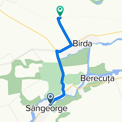
 Birda to DJ588A 104, Sângeorge
- Distance
- 7.4 km
- Ascent
- 9 m
- Descent
- 30 m
- Location
- Birda, Timiș County, Romania
 Donjonul din Varset
- Distance
- 49.9 km
- Ascent
- 348 m
- Descent
- 80 m
- Location
- Birda, Timiș County, Romania
 DJ588A 219, Sângeorge to Birda
- Distance
- 5.9 km
- Ascent
- 22 m
- Descent
- 3 m
- Location
- Birda, Timiș County, Romania
 DJ588A, Mânăstire to DC169 240, Sculia
- Distance
- 10.4 km
- Ascent
- 19 m
- Descent
- 10 m
- Location
- Birda, Timiș County, Romania
Open it in the app