

Cyklotrasa Rytíře Zbyhoně (50km)
A cycling route starting in Mostek, Královéhradecký kraj, Czechia.
Overview
About this route
<p><strong>ROUTE DESCRIPTION</strong></p>
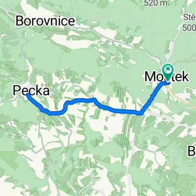
<p>We will start our ride at the cultural center in Úhlejov, descending 500 m along the main road to a junction, where we turn left towards Třebihošť on cycling route number 4086. At the junction in Třebihošť near the Motorest U Lípy, we turn right onto cycling route number 4136 and continue straight through Dolní Dehtov. After crossing the main road, we proceed through the villages of Zábřezí-Řečice, Doubravice, and Zálesí. On the descent through the forest before Dvůr Králové, at the junction, we go right on the cycle route towards Libotov. After 100 m we turn left onto a forest path on cycle route number 4133, which runs along the railway line past the Krakonošova viewpoint. At the end of the forest path, we turn left onto the road and join the yellow hiking trail. 500 m past the railway crossing, we turn right onto the Way of the Cross at the tourist junction named "Křížová cesta 21.století." At the junction, we turn left onto the red hiking trail under the railway bridge. After half a kilometre, we join a road still following the same route. After the bridge over the Elbe, we continue on the red trail that leads along the Elbe beneath the Hospital Kuks.</p>
<p>After visiting the beautiful garden at the hospital, we can return along the red trail to the junction (before the bridge), and just before the bridge continue straight on cycling route number 4087 through Stanovice to Choustníkovo Hradiště, where after crossing the main road we continue on the same cycle route through Ferdinandov and proceed along an asphalt forest road straight to Kocbeře (halfway along the forest road we leave the cycle route, which goes right). In Kocbeře, we turn right onto the main road and after 100 m turn left onto the road leading to Dvůr Králové. After half a kilometre, we turn right onto a field path and then at the end again right onto the road leading to Komárov, where we join the blue hiking trail. We follow this to the hospital where we turn left onto cycle route number 4088 leading out of town. This "Transverse Path" through meadows leads us to a forest road where after half a kilometre at a junction we turn down left, off the cycle path heading towards the dam. After a short descent, we arrive at a junction where we continue straight towards the Les Království dam.</p>
<p>From here, we proceed to Bílá Třemešná, where we join the main road right towards Nová Paka. After half a kilometre, we turn left towards Třebihošť. At the start of Třebihošť, we join cycle route 4086 and at the Motorest U Lípy turn left towards the finish at the cultural center, passing through the village of Šušpárek.</p>
Translated, show original (Polish)- -:--
- Duration
- 47.3 km
- Distance
- 472 m
- Ascent
- 472 m
- Descent
- ---
- Avg. speed
- ---
- Max. altitude

Route photos
\"")
Route quality
Waytypes & surfaces along the route
Waytypes
Road
22.2 km
(47 %)
Track
16.1 km
(34 %)
Surfaces
Paved
4.3 km
(9 %)
Unpaved
13.7 km
(29 %)
Ground
7.6 km
(16 %)
Gravel
3.8 km
(8 %)
Continue with Bikemap
Use, edit, or download this cycling route
You would like to ride Cyklotrasa Rytíře Zbyhoně (50km) or customize it for your own trip? Here is what you can do with this Bikemap route:
Free features
- Save this route as favorite or in collections
- Copy & plan your own version of this route
- Sync your route with Garmin or Wahoo
Premium features
Free trial for 3 days, or one-time payment. More about Bikemap Premium.
- Navigate this route on iOS & Android
- Export a GPX / KML file of this route
- Create your custom printout (try it for free)
- Download this route for offline navigation
Discover more Premium features.
Get Bikemap PremiumFrom our community
Other popular routes starting in Mostek
 Cyklotrasa Rytíře Zbyhoně (25km)
- Distance
- 25.3 km
- Ascent
- 375 m
- Descent
- 373 m
- Location
- Mostek, Královéhradecký kraj, Czechia
 gfhfhfgh
- Distance
- 3.2 km
- Ascent
- 224 m
- Descent
- 0 m
- Location
- Mostek, Královéhradecký kraj, Czechia
 Pěší pochod Rytíře Zbyhoně (23km)
- Distance
- 22.2 km
- Ascent
- 528 m
- Descent
- 528 m
- Location
- Mostek, Královéhradecký kraj, Czechia
 Pěší pochod Rytíře Zbyhoně (18km)
- Distance
- 17.7 km
- Ascent
- 443 m
- Descent
- 441 m
- Location
- Mostek, Královéhradecký kraj, Czechia
 Pecka2
- Distance
- 16.3 km
- Ascent
- 265 m
- Descent
- 265 m
- Location
- Mostek, Královéhradecký kraj, Czechia
 Cyklotrasa Rytíře Zbyhoně (38km)
- Distance
- 40.9 km
- Ascent
- 679 m
- Descent
- 678 m
- Location
- Mostek, Královéhradecký kraj, Czechia
 Pěší pochod Rytíře Zbyhoně (23km)
- Distance
- 23 km
- Ascent
- 499 m
- Descent
- 499 m
- Location
- Mostek, Královéhradecký kraj, Czechia
 Pěší pochod Rytíře Zbyhoně (18km)
- Distance
- 19.7 km
- Ascent
- 408 m
- Descent
- 408 m
- Location
- Mostek, Královéhradecký kraj, Czechia
Open it in the app