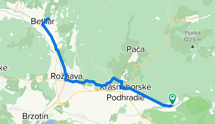
Kaštieľ Betliar
A cycling route starting in Rožňava, Košice Region, Slovakia.
Overview
About this route
- -:--
- Duration
- 33.3 km
- Distance
- 452 m
- Ascent
- 452 m
- Descent
- ---
- Avg. speed
- ---
- Max. altitude
Route quality
Waytypes & surfaces along the route
Waytypes
Track
10.5 km
(32 %)
Busy road
7 km
(21 %)
Surfaces
Paved
12.4 km
(37 %)
Unpaved
13.3 km
(40 %)
Asphalt
12.2 km
(37 %)
Ground
10.8 km
(32 %)
Route highlights
Points of interest along the route
Photo after 16.6 km
Kaštieľ Betliar
Continue with Bikemap
Use, edit, or download this cycling route
You would like to ride Kaštieľ Betliar or customize it for your own trip? Here is what you can do with this Bikemap route:
Free features
- Save this route as favorite or in collections
- Copy & plan your own version of this route
- Sync your route with Garmin or Wahoo
Premium features
Free trial for 3 days, or one-time payment. More about Bikemap Premium.
- Navigate this route on iOS & Android
- Export a GPX / KML file of this route
- Create your custom printout (try it for free)
- Download this route for offline navigation
Discover more Premium features.
Get Bikemap PremiumFrom our community
Other popular routes starting in Rožňava
- Soroska - Silica - Silicka ladnica
- Distance
- 32.2 km
- Ascent
- 403 m
- Descent
- 403 m
- Location
- Rožňava, Košice Region, Slovakia
- Sunday Track In Lúčka
- Distance
- 18.8 km
- Ascent
- 815 m
- Descent
- 823 m
- Location
- Rožňava, Košice Region, Slovakia
- Rožňava - Kružná - Silica - Silická Brezová - Plešivec
- Distance
- 57 km
- Ascent
- 711 m
- Descent
- 714 m
- Location
- Rožňava, Košice Region, Slovakia
- Rožňava- Brzotín- Slavec- Gombasek / jaskyňa
- Distance
- 13.2 km
- Ascent
- 66 m
- Descent
- 84 m
- Location
- Rožňava, Košice Region, Slovakia
- chata Volovec
- Distance
- 13.8 km
- Ascent
- 1,126 m
- Descent
- 365 m
- Location
- Rožňava, Košice Region, Slovakia
- Úhornianske sedlo- Kaplnka- Jezero
- Distance
- 8 km
- Ascent
- 142 m
- Descent
- 502 m
- Location
- Rožňava, Košice Region, Slovakia
- Soroska - Dievcenska skala
- Distance
- 17.3 km
- Ascent
- 632 m
- Descent
- 637 m
- Location
- Rožňava, Košice Region, Slovakia
- Test
- Distance
- 24.7 km
- Ascent
- 446 m
- Descent
- 446 m
- Location
- Rožňava, Košice Region, Slovakia
Open it in the app