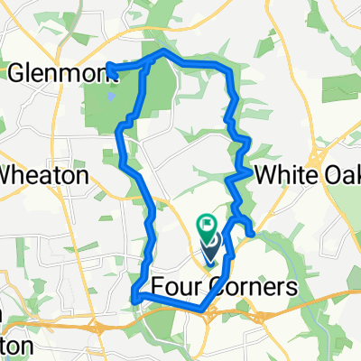
Historic Homes and Urban Nature Trails Ride (Extended)
- 20.2 km
- 228 m
- 227 m
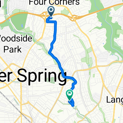
- Four Corners, Maryland, United States
A fairly flat leisurely route through Silver Spring neighborhoods and local parks. Most of the route is paved, but some stretches are dirt or gravel.
Start at Four Corners Local Park. Pick up Royalton Road on the north corner of the park and turn right. Turn right again onto Dennis, which turns into Lockridge Drive. Take the first right, then right again, and right again onto Mountain Quail Road. Walk the bike up Kinsman View Circle a little way. On the right is Holly View, the oldest house in Silver Spring, dating from 1783. Continue along Mountain Quail Road and turn left onto Eastwood Avenue and right onto Southwood. Take the first left onto Sutherland.
Here in the Northwood Park neighborhood, between 1938 and 1939, developers drawing inspiration from the upcoming 1939 World’s Fair constructed a number of state-of-the-art homes.
Stop at the intersection of Edgewood Avenue and Sutherland Road. On your right, immediately after the intersection with Edgewood Avenue sits a brick Tudor Revival home. It was built in 1938 as a Washington Gas Light Company model home. Turn right onto Sutherland and check out the Colonial Revival Cape Cod house to your left: this is an exact copy of the 1939 World’s Fair “Town of Tomorrow” demonstration home No. 15, the “Triple Insulated Home”.
Turn right on Timberwood and then left on Lorain, then cross University Boulevard at the crosswalk. Turn left at Lanark Way and then right on Sutherland Road past the concrete homes of the Polychrome Historic District.
The Polychrome houses are 9919, 9923, and 9925 Sutherland Road (and behind them at 9900 and 9904 Colesville Road). These homes were built by John Joseph Earley in 1934 and 1935. Earley used precast concrete panels with brightly colored aggregate to produce the polychrome effect, with Art Deco details. Earley was interested in the use of mass-production techniques to produce small, inexpensive houses, paralleling Frank Lloyd Wright's Usonian house concepts.
Follow Sutherland as it becomes Forest Glen Road, past Forest Glen Deli and South Four Corners Park.
After passing the Schweinhaut Senior Center and reaching Argyle Park on your left, turn right onto Godwin, then cross Sligo Creek Parkway and pick up the Sligo Creek Trail heading north.
Cycle upstream. The route crosses Sligo Creek Parkway at a small parking lot and (if you can find the entrance - it's about twenty yards to the south) you can pick up the Northwood Chesapeake Bay Trail heading northeast here, but if you fancy a bite to eat, carry on upstream on the Sligo Creek Trail and cross University Boulevard again. After about 200 yards you'll see an outdoor mall on the right of the trail: here you can stop for a meal at one of the eateries, or keep going through the mall and past Kemp Mill Urban Park. Keep going straight onto Lamberton Drive. Stay on this road until it ends at the entrance to the Northwest Branch Trail. This is basically a hiking trail - but it is possible to cycle along it from here. However, it may be best to dismount and walk with the bike if it gets too rough. Across the creek is the Rachel Carson Greenway Trail. Just half a mile east of here sits Rachel Carson's home, where she wrote "Silent Spring", the book that started the modern environmental movement. Head downstream as the Northwest Branch widens and becomes the Burnt Mills Reservoir. At the southern end of the reservoir is a dam (you'll need to walk the bike here – sometimes fallen trees block the trail), and on the other side of Colesville Road there is an old mill building.
The Burnt Mills Dam has a long history. The original dam and mill were built here in the 1700s. The mill burned down in 1788, hence the name Burnt Mills. Shortly thereafter a new mill was built and modified quite a few times over the years. Eventually a concrete dam was built in the present location with a mill race that delivered water under Colesville Road to the mill building located on the south side. The mill, which produced flour and ground corn meal, stayed in continuous use until about 1920. After the mill closed the surrounding land was donated to the Boy Scouts of America where they established a camp named for President Woodrow Wilson. For a time the boy scouts used the old mill building as a meeting hall.
If you have time, south of the dam across Colesville Road, beyond the Robert B. Morse Water Filtration Plant, which was built between 1934 and 1936, there is a hiking trail. It is not suitable for bicycles and is not easy walking but if you park the bike you will find that there is a fine gorge and series of water falls located there. It was this sort of location that proved a perfect site for a mill as the rapid drop off of water through the gorge provided ample water power to drive a mill wheel.
After seeing the dam, head back a little way along the trail, there is a path here that takes you back to Lockridge Drive, which turns into Dennis Avenue. Four Corners Park, where you started, is on the left.

Path
3.3 km26 %Cycleway
3.3 km26 %Paved
9.1 km(73 %)Unpaved
3.1 km(25 %)Asphalt
9 km72 %Ground
3.1 km25 %
North Four Corners Local Park

130 Kinsman View Circle. "Holly View". Difficult to see from the street, so it may be best to skip this one. This is the oldest house in Silver Spring. The house was built before 1783 by a Josiah Beane. In the 1880s, ownership of the property passed to Colonel Oliver Kinsman, a Union veteran of the Civil War.

10216 Lorain, Washington Gas Light Company model home built in 1938, inspired by the upcoming 1939 World's Fair.

10163 Sutherland Rd, 1939 World's Fair "Town of Tomorrow" Demonstration Home #15, the "Johns-Manville Triple-Insulated House".

Polychrome Historic District: 9900 and 9904 Colesville Road; 9919, 9923, and 9925 Sutherland Road. These homes were built by John Joseph Earley in 1934 and 1935. Earley used precast concrete panels with brightly colored aggregate to produce the polychrome effect, with Art Deco details. Earley was interested in the use of mass-production to produce small, inexpensive houses.

Four Corners Deli.
Four Corners, built c. 1939.

South Four Corners Park.

Schweinhaut Senior Center.

Argyle Park.

Forest Grove Neighborhood Park
Sligo Woods Neighborhood, primarily built in the late 1930s, with construction nearly completed by 1940

Breewood Neighborhood Park
Colt Terrace Neighborhood Park
Brookside Gardens Visitor Center

Cafes, Restaurants.

Kemp Mill Urban Park.
Kemp Mill Estates, built c. 1962.
Kemp Mill Neighborhood

Harper Cabin
Wheaton Park Stables
Evan Thomas, a Quaker minister and political activist, settled the land and established a frame saw and grist mill near this location in 1745, which he named Thomas’ Mill. The mill was sold to Aaron Dyer in 1816, who sold it to Francis Valdenar in 1833. In the 1830s, a small settlement called Claysville sprang up around the mill. The settlement was renamed Kemp Mill in 1857 when George Kemp purchased the mill from Valdenar, and the Kemp family managed the mill until 1905. The mill eventually burned down in 1919, marking the end of 174 years of continuous operation.
Prehistoric Dwellings

Prehistoric Rock Shelter. Beginning about 1000 BCE, local tribes used these natural rock formations as shelters. Discarded tools found in the vicinity of these rocks suggest people gathered here while hunting and gathering food to supplement their agricultural produce.
Kemp Mill Estates Local Park

11701 Berwick Road. Rachel Carson's home, where she wrote "Silent Spring", the book that started the modern environmental movement.

The trail here leads to a small gorge with East Coast Fall Line boulders and waterfalls. These boulders are found in the geological zone where the harder, older rocks of the Piedmont region meet the soft, sandy sediments of the Coastal Plain. They are not from glacial deposition but are remnants of the more resistant, crystalline bedrock that has been exposed and shaped by river erosion.

Burnt Mills West Special Park

Burnt Mills Dam.

Robert B. Morse Water Filtration Plant, built 1934-36.
Free trial for 3 days, or one-time payment. More about Bikemap Premium.
Discover more Premium features.
Get Bikemap PremiumOpen it in the app