

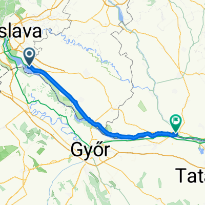
Gabčíkovo
A cycling route starting in Šamorín, Trnava Region, Slovakia.
Overview
About this route
- -:--
- Duration
- 92.5 km
- Distance
- 38 m
- Ascent
- 29 m
- Descent
- ---
- Avg. speed
- ---
- Max. altitude

Route quality
Waytypes & surfaces along the route
Waytypes
Cycleway
48.1 km
(52 %)
Road
7.4 km
(8 %)
Surfaces
Paved
62.9 km
(68 %)
Asphalt
60.1 km
(65 %)
Paved (undefined)
1.9 km
(2 %)
Continue with Bikemap
Use, edit, or download this cycling route
You would like to ride Gabčíkovo or customize it for your own trip? Here is what you can do with this Bikemap route:
Free features
- Save this route as favorite or in collections
- Copy & plan your own version of this route
- Split it into stages to create a multi-day tour
- Sync your route with Garmin or Wahoo
Premium features
Free trial for 3 days, or one-time payment. More about Bikemap Premium.
- Navigate this route on iOS & Android
- Export a GPX / KML file of this route
- Create your custom printout (try it for free)
- Download this route for offline navigation
Discover more Premium features.
Get Bikemap PremiumFrom our community
Other popular routes starting in Šamorín
 a Duna víztározó körül 2015.04.19.
- Distance
- 100 km
- Ascent
- 61 m
- Descent
- 61 m
- Location
- Šamorín, Trnava Region, Slovakia
 Čilistov X-BIONIC SPHERE-Kyselica-Horný Bar-Gabčíkovo-Čilistov X-BIONIC SPHERE
- Distance
- 50.8 km
- Ascent
- 33 m
- Descent
- 33 m
- Location
- Šamorín, Trnava Region, Slovakia
 Day 2 - Šamorín - Komárno
- Distance
- 80.4 km
- Ascent
- 75 m
- Descent
- 88 m
- Location
- Šamorín, Trnava Region, Slovakia
 R: Okolo Hrušovskej zdrže a cez kompu (Kyselica - Prístavný most)
- Distance
- 62.6 km
- Ascent
- 29 m
- Descent
- 26 m
- Location
- Šamorín, Trnava Region, Slovakia
 Burgenland
- Distance
- 225.1 km
- Ascent
- 268 m
- Descent
- 270 m
- Location
- Šamorín, Trnava Region, Slovakia
 Kyselica - Gabčíkovo a späť
- Distance
- 53.7 km
- Ascent
- 72 m
- Descent
- 72 m
- Location
- Šamorín, Trnava Region, Slovakia
 2014_Slovakia_Danube_Šamorin_Vojka nad Dunajom
- Distance
- 46.2 km
- Ascent
- 23 m
- Descent
- 21 m
- Location
- Šamorín, Trnava Region, Slovakia
 najvacsi chill-smrt
- Distance
- 58.9 km
- Ascent
- 45 m
- Descent
- 48 m
- Location
- Šamorín, Trnava Region, Slovakia
Open it in the app