

Oberlehn - Tour
A cycling route starting in Luthern, Canton of Lucerne, Switzerland.
Overview
About this route
to the Bikehotel > www.kroneluthern.ch
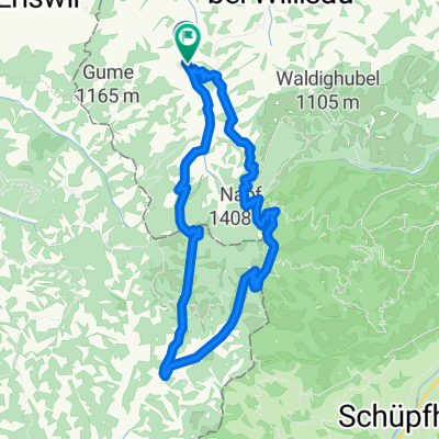
Beautiful circular tour starting and ending in the alpine village of Luthern
This tour takes you first downstream, along the watercourse of the Luther. After a gentle warm-up, you will reach the first of five hill zones. After the descent into the valley, you will soon climb back up to the Obere Hickere. After a comfortable descent, you will arrive in the herb village Hergiswil. And you are already facing the third ascent, which takes you to the Mättenberg. Enjoy the view before you guide your vehicle into the next valley. From the lowest point of this tour, you will now climb steadily up to the highest point. The stunning view of the Napf, Pilatus, Rigi, Jura, and the Mittelland rewards the effort.
From now on, the tour is pure enjoyment, the gently sloping path leads to the parking lot Wiggernhütte, where the final difficult trail through the woods is a very popular hiking path. After crossing the stream, a forest road winds playfully between the trees and firs towards the last rise.
An almost never-ending natural road brings you closer to the goal, later you will merge into a dirt path, from where the first views of the target are allowed. An asphalt road hopefully brings you back safely and in good spirits to Luthern-Dorf.
- -:--
- Duration
- 38 km
- Distance
- 791 m
- Ascent
- 791 m
- Descent
- ---
- Avg. speed
- ---
- Max. altitude
Route quality
Waytypes & surfaces along the route
Waytypes
Track
22 km
(58 %)
Quiet road
11.4 km
(30 %)
Surfaces
Paved
17.5 km
(46 %)
Unpaved
6.1 km
(16 %)
Paved (undefined)
8.7 km
(23 %)
Asphalt
6.8 km
(18 %)
Continue with Bikemap
Use, edit, or download this cycling route
You would like to ride Oberlehn - Tour or customize it for your own trip? Here is what you can do with this Bikemap route:
Free features
- Save this route as favorite or in collections
- Copy & plan your own version of this route
- Sync your route with Garmin or Wahoo
Premium features
Free trial for 3 days, or one-time payment. More about Bikemap Premium.
- Navigate this route on iOS & Android
- Export a GPX / KML file of this route
- Create your custom printout (try it for free)
- Download this route for offline navigation
Discover more Premium features.
Get Bikemap PremiumFrom our community
Other popular routes starting in Luthern
 A04 Hergiswil Napf
- Distance
- 25.8 km
- Ascent
- 578 m
- Descent
- 577 m
- Location
- Luthern, Canton of Lucerne, Switzerland
 Napfrundfahrt
- Distance
- 107 km
- Ascent
- 897 m
- Descent
- 897 m
- Location
- Luthern, Canton of Lucerne, Switzerland
 Fritzefluh Tour
- Distance
- 39.5 km
- Ascent
- 871 m
- Descent
- 868 m
- Location
- Luthern, Canton of Lucerne, Switzerland
 Napf-Luzern
- Distance
- 39.8 km
- Ascent
- 199 m
- Descent
- 1,161 m
- Location
- Luthern, Canton of Lucerne, Switzerland
 Lüderenalp Tour
- Distance
- 66.4 km
- Ascent
- 1,702 m
- Descent
- 1,702 m
- Location
- Luthern, Canton of Lucerne, Switzerland
 Ahornalp-Luthern
- Distance
- 7.4 km
- Ascent
- 41 m
- Descent
- 400 m
- Location
- Luthern, Canton of Lucerne, Switzerland
 Oberlehn - Tour
- Distance
- 38 km
- Ascent
- 791 m
- Descent
- 791 m
- Location
- Luthern, Canton of Lucerne, Switzerland
 Mettlen Tour
- Distance
- 32.5 km
- Ascent
- 880 m
- Descent
- 875 m
- Location
- Luthern, Canton of Lucerne, Switzerland
Open it in the app