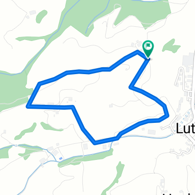
Scheidegg Tour
A cycling route starting in Luthern, Canton of Lucerne, Switzerland.
Overview
About this route
<span style="font-family: Arial, Helvetica, sans-serif; font-size: 11px;">zum Bikehotel > www.kroneluthern.ch</span>
Diese kurze Rundtour ist ideal für Bike und Flyer und kann auch in umgekehrter Richtung gefahren werden.
Wer`s zuerst etwas gemütlicher mag, sollte der Tour Richtung Luthernbad folgen. Schon bald beginnt der Aufstiegauf eine Hügelzone , welche sich wie eine lange Zunge bis ins Tal erstreckt, zur Gross Scheidegg. Von da an führt eine Waldstrasse durch den Chessel zum Müttebüel. Seien Sie nicht überrascht, wenn Sie plötzlich aus nächster Nähe Gemsen beobachten können.
Nun verlassen Sie für kurze Zeit die Gemeinde Luthern und umfahren über Hochschwändi und Buechighus einen Hügel, um via Chatzerschwand wieder in die Gemeinde Luthern zu gelangen.
Jetzt beginnt eine herrliche Abfahrt, mit wunderbarer Sicht ins Mittelland und zur Jurakette, zurück zum Ausgangspunkt.<span style="text-decoration: underline;"><span style="font-size: 18.0pt;"></span></span>
- -:--
- Duration
- 17.7 km
- Distance
- 564 m
- Ascent
- 559 m
- Descent
- ---
- Avg. speed
- ---
- Avg. speed
Route quality
Waytypes & surfaces along the route
Waytypes
Track
12.8 km
(72 %)
Access road
3.5 km
(19 %)
Surfaces
Paved
6.7 km
(38 %)
Unpaved
5.2 km
(29 %)
Paved (undefined)
5.3 km
(30 %)
Gravel
2.5 km
(14 %)
Continue with Bikemap
Use, edit, or download this cycling route
You would like to ride Scheidegg Tour or customize it for your own trip? Here is what you can do with this Bikemap route:
Free features
- Save this route as favorite or in collections
- Copy & plan your own version of this route
- Sync your route with Garmin or Wahoo
Premium features
Free trial for 3 days, or one-time payment. More about Bikemap Premium.
- Navigate this route on iOS & Android
- Export a GPX / KML file of this route
- Create your custom printout (try it for free)
- Download this route for offline navigation
Discover more Premium features.
Get Bikemap PremiumFrom our community
Other popular routes starting in Luthern
- Oberlehn - Tour
- Distance
- 38 km
- Ascent
- 791 m
- Descent
- 791 m
- Location
- Luthern, Canton of Lucerne, Switzerland
- A04 Hergiswil Napf
- Distance
- 25.8 km
- Ascent
- 578 m
- Descent
- 577 m
- Location
- Luthern, Canton of Lucerne, Switzerland
- Lüderenalp Tour
- Distance
- 66.4 km
- Ascent
- 1,702 m
- Descent
- 1,702 m
- Location
- Luthern, Canton of Lucerne, Switzerland
- Napf - Hergiswil
- Distance
- 13.2 km
- Ascent
- 78 m
- Descent
- 823 m
- Location
- Luthern, Canton of Lucerne, Switzerland
- Änzi Tour
- Distance
- 20.7 km
- Ascent
- 639 m
- Descent
- 636 m
- Location
- Luthern, Canton of Lucerne, Switzerland
- Mettlen Tour
- Distance
- 32.5 km
- Ascent
- 880 m
- Descent
- 875 m
- Location
- Luthern, Canton of Lucerne, Switzerland
- Fritzefluh Tour
- Distance
- 39.5 km
- Ascent
- 871 m
- Descent
- 868 m
- Location
- Luthern, Canton of Lucerne, Switzerland
- Ahornalp-Luthern
- Distance
- 7.4 km
- Ascent
- 41 m
- Descent
- 400 m
- Location
- Luthern, Canton of Lucerne, Switzerland