2019-20 Issoire Circle toward Condat-lès-Montboissier
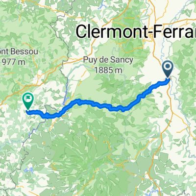
A cycling route starting in Issoire, Auvergne-Rhône-Alpes, France.
Overview
About this route
In 2019, we did self-supported touring for a little less than 2 months from mid-September through early November.
Day 20 - Issoire - Circle toward Condat-lès-Montboissier
We started out despite threatening skies and found these roads east of Issoire to be exceptional. Most were very low traffic and the scenery was wonderful. We highly recommend them.
A few kilometers before reaching Condat-lès-Montboissier, rain started pelting down hard enough that we chose to retrace our steps rather than continue our planned circle.
- -:--
- Duration
- 41.7 km
- Distance
- 619 m
- Ascent
- 620 m
- Descent
- ---
- Avg. speed
- ---
- Avg. speed
Route photos
Route quality
Waytypes & surfaces along the route
Waytypes
Road
28.2 km
(68 %)
Busy road
9.2 km
(22 %)
Surfaces
Paved
21.4 km
(51 %)
Asphalt
21.4 km
(51 %)
Undefined
20.3 km
(49 %)
Continue with Bikemap
Use, edit, or download this cycling route
You would like to ride 2019-20 Issoire Circle toward Condat-lès-Montboissier or customize it for your own trip? Here is what you can do with this Bikemap route:
Free features
- Save this route as favorite or in collections
- Copy & plan your own version of this route
- Sync your route with Garmin or Wahoo
Premium features
Free trial for 3 days, or one-time payment. More about Bikemap Premium.
- Navigate this route on iOS & Android
- Export a GPX / KML file of this route
- Create your custom printout (try it for free)
- Download this route for offline navigation
Discover more Premium features.
Get Bikemap PremiumFrom our community
Other popular routes starting in Issoire
- 2019-20 Issoire Circle toward Condat-lès-Montboissier
- Distance
- 41.7 km
- Ascent
- 619 m
- Descent
- 620 m
- Location
- Issoire, Auvergne-Rhône-Alpes, France
- 2019-21 Issoire Circle to St-Martin-des-Plains
- Distance
- 23.5 km
- Ascent
- 132 m
- Descent
- 134 m
- Location
- Issoire, Auvergne-Rhône-Alpes, France
- 15 Vichy
- Distance
- 86.7 km
- Ascent
- 594 m
- Descent
- 713 m
- Location
- Issoire, Auvergne-Rhône-Alpes, France
- DA Charity Etape 2011 Day 1
- Distance
- 149.1 km
- Ascent
- 2,371 m
- Descent
- 1,856 m
- Location
- Issoire, Auvergne-Rhône-Alpes, France
- Deutschland - Portugal (Berlin - Faro) FR 20 Issoire - Massiac
- Distance
- 55.9 km
- Ascent
- 365 m
- Descent
- 251 m
- Location
- Issoire, Auvergne-Rhône-Alpes, France
- De Impasse de l'Union 6, Issoire à Impasse de l'Union 2, Issoire
- Distance
- 17.5 km
- Ascent
- 387 m
- Descent
- 389 m
- Location
- Issoire, Auvergne-Rhône-Alpes, France
- TDF 13. Etappe Issoire - Roanne
- Distance
- 139.6 km
- Ascent
- 1,948 m
- Descent
- 2,047 m
- Location
- Issoire, Auvergne-Rhône-Alpes, France
- issoire
- Distance
- 84.2 km
- Ascent
- 1,023 m
- Descent
- 977 m
- Location
- Issoire, Auvergne-Rhône-Alpes, France
Open it in the app