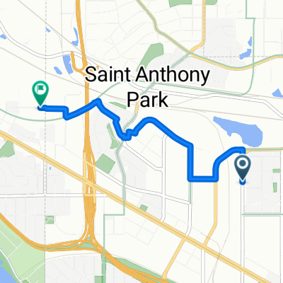
B2B00602 55113>55104 via Como Av, Lexington Pkwy, Hewitt Ave
A cycling route starting in Falcon Heights, Minnesota, United States.
Overview
About this route
There is a bike path that runs next to Lexington which is advised as it is a busy road.
Â
There is a bike bridge that crosses the rail yard, which you can access from Energy Park Dr.Â
- -:--
- Duration
- 7.7 km
- Distance
- 23 m
- Ascent
- 33 m
- Descent
- ---
- Avg. speed
- 299 m
- Max. altitude
Route quality
Waytypes & surfaces along the route
Waytypes
Cycleway
4 km
(52 %)
Quiet road
2.2 km
(29 %)
Surfaces
Paved
6.3 km
(82 %)
Asphalt
5.6 km
(73 %)
Concrete
0.6 km
(8 %)
Continue with Bikemap
Use, edit, or download this cycling route
You would like to ride B2B00602 55113>55104 via Como Av, Lexington Pkwy, Hewitt Ave or customize it for your own trip? Here is what you can do with this Bikemap route:
Free features
- Save this route as favorite or in collections
- Copy & plan your own version of this route
- Sync your route with Garmin or Wahoo
Premium features
Free trial for 3 days, or one-time payment. More about Bikemap Premium.
- Navigate this route on iOS & Android
- Export a GPX / KML file of this route
- Create your custom printout (try it for free)
- Download this route for offline navigation
Discover more Premium features.
Get Bikemap PremiumFrom our community
Other popular routes starting in Falcon Heights
- 50 mile Stillwater Loop
- Distance
- 79.7 km
- Ascent
- 468 m
- Descent
- 469 m
- Location
- Falcon Heights, Minnesota, United States
- 2019 Saint Paul Classic (long)
- Distance
- 49 km
- Ascent
- 178 m
- Descent
- 180 m
- Location
- Falcon Heights, Minnesota, United States
- B2B00017 - 55104 to 55402
- Distance
- 12.2 km
- Ascent
- 125 m
- Descent
- 155 m
- Location
- Falcon Heights, Minnesota, United States
- Saint Paul Saturday Stroll
- Distance
- 32.4 km
- Ascent
- 197 m
- Descent
- 198 m
- Location
- Falcon Heights, Minnesota, United States
- St. Paul Classic short loop
- Distance
- 22.8 km
- Ascent
- 200 m
- Descent
- 184 m
- Location
- Falcon Heights, Minnesota, United States
- B2B00444 55104>55119 via Minnehaha Ave W, Case Ave, Reaney Ave
- Distance
- 18.3 km
- Ascent
- 111 m
- Descent
- 94 m
- Location
- Falcon Heights, Minnesota, United States
- B2B00773 55104>55418 via Pelham Blvd, Transitway, Mpls Diag Trl, St Anthony Pkwy
- Distance
- 17.2 km
- Ascent
- 72 m
- Descent
- 81 m
- Location
- Falcon Heights, Minnesota, United States
- LOLOL
- Distance
- 57.5 km
- Ascent
- 187 m
- Descent
- 187 m
- Location
- Falcon Heights, Minnesota, United States
Open it in the app