

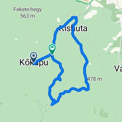
Telkibánya- Regéci vár- Sólyom-kő- Emlékhely- Pálos kolostorrom-Potácsháza kör
A cycling route starting in Gönc, Borsod-Abauj Zemplen county, Hungary.
Overview
About this route
- -:--
- Duration
- 44.8 km
- Distance
- 1,184 m
- Ascent
- 1,183 m
- Descent
- ---
- Avg. speed
- ---
- Max. altitude
Route quality
Waytypes & surfaces along the route
Waytypes
Track
36.3 km
(81 %)
Path
2.7 km
(6 %)
Surfaces
Paved
8.1 km
(18 %)
Unpaved
26.4 km
(59 %)
Ground
24.2 km
(54 %)
Asphalt
7.6 km
(17 %)
Continue with Bikemap
Use, edit, or download this cycling route
You would like to ride Telkibánya- Regéci vár- Sólyom-kő- Emlékhely- Pálos kolostorrom-Potácsháza kör or customize it for your own trip? Here is what you can do with this Bikemap route:
Free features
- Save this route as favorite or in collections
- Copy & plan your own version of this route
- Sync your route with Garmin or Wahoo
Premium features
Free trial for 3 days, or one-time payment. More about Bikemap Premium.
- Navigate this route on iOS & Android
- Export a GPX / KML file of this route
- Create your custom printout (try it for free)
- Download this route for offline navigation
Discover more Premium features.
Get Bikemap PremiumFrom our community
Other popular routes starting in Gönc
 Pálháza 30km körút
- Distance
- 14.2 km
- Ascent
- 80 m
- Descent
- 388 m
- Location
- Gönc, Borsod-Abauj Zemplen county, Hungary
 STEREO 10.2 Kőkapu-Pálháza
- Distance
- 8.5 km
- Ascent
- 25 m
- Descent
- 101 m
- Location
- Gönc, Borsod-Abauj Zemplen county, Hungary
 ROMANIA 2011 - 2 day
- Distance
- 120.7 km
- Ascent
- 181 m
- Descent
- 210 m
- Location
- Gönc, Borsod-Abauj Zemplen county, Hungary
 Múzeum út 8a., Telkibánya to Múzeum út 11., Telkibánya
- Distance
- 37.7 km
- Ascent
- 970 m
- Descent
- 980 m
- Location
- Gönc, Borsod-Abauj Zemplen county, Hungary
 A Borsó- és a Gergely-hegy titkai
- Distance
- 14.6 km
- Ascent
- 593 m
- Descent
- 595 m
- Location
- Gönc, Borsod-Abauj Zemplen county, Hungary
 Kőkapu-Kishuta-Nagyhuta (kör)
- Distance
- 19.4 km
- Ascent
- 433 m
- Descent
- 458 m
- Location
- Gönc, Borsod-Abauj Zemplen county, Hungary
 Kőkapu 2
- Distance
- 13 km
- Ascent
- 434 m
- Descent
- 433 m
- Location
- Gönc, Borsod-Abauj Zemplen county, Hungary
 Telkibánya 38 km-es kör
- Distance
- 37.8 km
- Ascent
- 559 m
- Descent
- 559 m
- Location
- Gönc, Borsod-Abauj Zemplen county, Hungary
Open it in the app