

Ruta deportiva en Rumiñahui
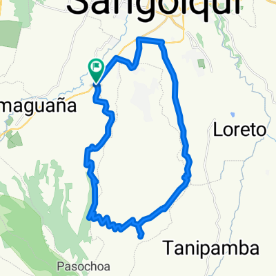
A cycling route starting in Sangolquí, Pichincha, Ecuador.
Overview
About this route
- 1 h 25 min
- Duration
- 31.5 km
- Distance
- 332 m
- Ascent
- 333 m
- Descent
- 22.3 km/h
- Avg. speed
- ---
- Max. altitude

Continue with Bikemap
Use, edit, or download this cycling route
You would like to ride Ruta deportiva en Rumiñahui or customize it for your own trip? Here is what you can do with this Bikemap route:
Free features
- Save this route as favorite or in collections
- Copy & plan your own version of this route
- Sync your route with Garmin or Wahoo
Premium features
Free trial for 3 days, or one-time payment. More about Bikemap Premium.
- Navigate this route on iOS & Android
- Export a GPX / KML file of this route
- Create your custom printout (try it for free)
- Download this route for offline navigation
Discover more Premium features.
Get Bikemap PremiumFrom our community
Other popular routes starting in Sangolquí
 LAGARTIJAS BIKE RACE 15K - 30K
- Distance
- 15.6 km
- Ascent
- 608 m
- Descent
- 609 m
- Location
- Sangolquí, Pichincha, Ecuador
 RUTA DE LOS VOLCANES
- Distance
- 37.8 km
- Ascent
- 1,781 m
- Descent
- 612 m
- Location
- Sangolquí, Pichincha, Ecuador
 Vuelta al Pasochoa
- Distance
- 70.9 km
- Ascent
- 1,437 m
- Descent
- 1,422 m
- Location
- Sangolquí, Pichincha, Ecuador
 ANTISANA
- Distance
- 27.6 km
- Ascent
- 1,353 m
- Descent
- 495 m
- Location
- Sangolquí, Pichincha, Ecuador
 entrada a cotogchoa
- Distance
- 23.5 km
- Ascent
- 424 m
- Descent
- 427 m
- Location
- Sangolquí, Pichincha, Ecuador
 parque
- Distance
- 17.5 km
- Ascent
- 582 m
- Descent
- 550 m
- Location
- Sangolquí, Pichincha, Ecuador
 Amaguaña - Pasochoa 2011
- Distance
- 32.9 km
- Ascent
- 913 m
- Descent
- 913 m
- Location
- Sangolquí, Pichincha, Ecuador
 Cotohurco
- Distance
- 30.4 km
- Ascent
- 1,084 m
- Descent
- 1,084 m
- Location
- Sangolquí, Pichincha, Ecuador
Open it in the app