

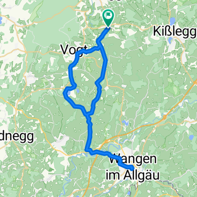
Eintürnenberg-Aussichtspunkt-Hochberg-Eintürnenberg
A cycling route starting in Wolfegg, Baden-Wurttemberg, Germany.
Overview
About this route
Wolfegg; Windbühl; Untersteg; Rochus Chapel-Baumann; Hochberg viewpoint; Felbers viewpoint; Herfatz; Röhren moss; Allewinden; Sommerried; Langenacker; Unter-Oberried garden; Holdenreute; Fountain; Eintürnenberg
- 3 h 29 min
- Duration
- 51.3 km
- Distance
- 567 m
- Ascent
- 570 m
- Descent
- 14.7 km/h
- Avg. speed
- ---
- Max. altitude
Route quality
Waytypes & surfaces along the route
Waytypes
Quiet road
34.9 km
(68 %)
Road
9.7 km
(19 %)
Surfaces
Paved
39 km
(76 %)
Unpaved
2.6 km
(5 %)
Asphalt
38 km
(74 %)
Pebblestone
1.5 km
(3 %)
Continue with Bikemap
Use, edit, or download this cycling route
You would like to ride Eintürnenberg-Aussichtspunkt-Hochberg-Eintürnenberg or customize it for your own trip? Here is what you can do with this Bikemap route:
Free features
- Save this route as favorite or in collections
- Copy & plan your own version of this route
- Sync your route with Garmin or Wahoo
Premium features
Free trial for 3 days, or one-time payment. More about Bikemap Premium.
- Navigate this route on iOS & Android
- Export a GPX / KML file of this route
- Create your custom printout (try it for free)
- Download this route for offline navigation
Discover more Premium features.
Get Bikemap PremiumFrom our community
Other popular routes starting in Wolfegg
 Radwallfahrt 2010
- Distance
- 25.4 km
- Ascent
- 267 m
- Descent
- 272 m
- Location
- Wolfegg, Baden-Wurttemberg, Germany
 Wolfegg-Bad Waldsee- Eintürnen-Wlfegg 32
- Distance
- 34.7 km
- Ascent
- 345 m
- Descent
- 332 m
- Location
- Wolfegg, Baden-Wurttemberg, Germany
 Eintürnenberg-Aussichtspunkt-Hochberg-Eintürnenberg
- Distance
- 51.3 km
- Ascent
- 567 m
- Descent
- 570 m
- Location
- Wolfegg, Baden-Wurttemberg, Germany
 Wangen, Kongo
- Distance
- 38.1 km
- Ascent
- 620 m
- Descent
- 620 m
- Location
- Wolfegg, Baden-Wurttemberg, Germany
 Feierabend Tour
- Distance
- 37.5 km
- Ascent
- 322 m
- Descent
- 322 m
- Location
- Wolfegg, Baden-Wurttemberg, Germany
 Aussichtspukt Riefenstock -
- Distance
- 67.8 km
- Ascent
- 1,049 m
- Descent
- 1,046 m
- Location
- Wolfegg, Baden-Wurttemberg, Germany
 Flowi Trails zur und von der Süh
- Distance
- 33 km
- Ascent
- 295 m
- Descent
- 296 m
- Location
- Wolfegg, Baden-Wurttemberg, Germany
 Berg nach Berg 7/1
- Distance
- 70.8 km
- Ascent
- 726 m
- Descent
- 760 m
- Location
- Wolfegg, Baden-Wurttemberg, Germany
Open it in the app