

BF6 Matre Solund
A cycling route starting in Mo, Hordaland, Norway.
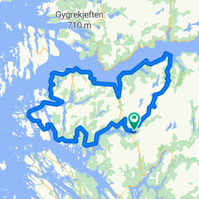
Overview
About this route
From Matre follow the mignificent old road outside the tunnels. The road from 1910 have "Stabbestein" as fenses. Be careful, spesially with small kids. If you come the other way drive slowly down becase of possible holes.
You have to use E39 at two places: Haugsvær and before Instefjorden.
At Brekke you find shops and Brekkestranda Fjord Lodge. Later you pass Botnen Camping. Thake the ferry fra Rutledal. At Solund the area has totaly changed before you reach Hardbakke and "Internatet" lodge.
- -:--
- Duration
- 95.4 km
- Distance
- 1,801 m
- Ascent
- 2,181 m
- Descent
- ---
- Avg. speed
- ---
- Max. altitude

Continue with Bikemap
Use, edit, or download this cycling route
You would like to ride BF6 Matre Solund or customize it for your own trip? Here is what you can do with this Bikemap route:
Free features
- Save this route as favorite or in collections
- Copy & plan your own version of this route
- Split it into stages to create a multi-day tour
- Sync your route with Garmin or Wahoo
Premium features
Free trial for 3 days, or one-time payment. More about Bikemap Premium.
- Navigate this route on iOS & Android
- Export a GPX / KML file of this route
- Create your custom printout (try it for free)
- Download this route for offline navigation
Discover more Premium features.
Get Bikemap PremiumFrom our community
Other popular routes starting in Mo
 Stølsheimen Vest: Fjordsykkelruta
- Distance
- 217.5 km
- Ascent
- 1,751 m
- Descent
- 1,735 m
- Location
- Mo, Hordaland, Norway
 Stølsheimen Vest: Fjordsykkelruta
- Distance
- 217.5 km
- Ascent
- 2,041 m
- Descent
- 2,041 m
- Location
- Mo, Hordaland, Norway
 Stordalen: Anleggsveien
- Distance
- 10.6 km
- Ascent
- 263 m
- Descent
- 348 m
- Location
- Mo, Hordaland, Norway
 BF5 Matre Bjordal Ortnevik
- Distance
- 59.4 km
- Ascent
- 3,145 m
- Descent
- 3,126 m
- Location
- Mo, Hordaland, Norway
 Stølsheimen Vest
- Distance
- 152.3 km
- Ascent
- 1,505 m
- Descent
- 1,504 m
- Location
- Mo, Hordaland, Norway
 Rock cycling in Haugsdalen and Engleberget
- Distance
- 11.5 km
- Ascent
- 557 m
- Descent
- 694 m
- Location
- Mo, Hordaland, Norway
 Matre - Bjordal
- Distance
- 34.2 km
- Ascent
- 1,977 m
- Descent
- 1,977 m
- Location
- Mo, Hordaland, Norway
 BF2 Haugsdalen
- Distance
- 13.5 km
- Ascent
- 2,285 m
- Descent
- 2,285 m
- Location
- Mo, Hordaland, Norway
Open it in the app