

Medieval Clopton
A cycling route starting in Baldock, England, United Kingdom.
Overview
About this route
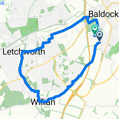
Route goes through Clopton, an abandoned Medieval Black Death village (Marked with spikes), and with a Templars plague hospital nearby. OS map verified Bridleways, Byways, and Restricted Byways - legal for bikes. (Anti-biotics not required). Ordnance Survey Maps required: 193 - Luton & Stevenage; and 208 - Bedford & St Neots.
- -:--
- Duration
- 43.7 km
- Distance
- 223 m
- Ascent
- 225 m
- Descent
- ---
- Avg. speed
- ---
- Max. altitude

Continue with Bikemap
Use, edit, or download this cycling route
You would like to ride Medieval Clopton or customize it for your own trip? Here is what you can do with this Bikemap route:
Free features
- Save this route as favorite or in collections
- Copy & plan your own version of this route
- Sync your route with Garmin or Wahoo
Premium features
Free trial for 3 days, or one-time payment. More about Bikemap Premium.
- Navigate this route on iOS & Android
- Export a GPX / KML file of this route
- Create your custom printout (try it for free)
- Download this route for offline navigation
Discover more Premium features.
Get Bikemap PremiumFrom our community
Other popular routes starting in Baldock
 Hatley Wood Spaghetti
- Distance
- 64.8 km
- Ascent
- 242 m
- Descent
- 244 m
- Location
- Baldock, England, United Kingdom
 Thumbs Up Barton
- Distance
- 53.8 km
- Ascent
- 361 m
- Descent
- 362 m
- Location
- Baldock, England, United Kingdom
 Broken Greenery
- Distance
- 25.6 km
- Ascent
- 174 m
- Descent
- 172 m
- Location
- Baldock, England, United Kingdom
 Toucan
- Distance
- 26.3 km
- Ascent
- 212 m
- Descent
- 212 m
- Location
- Baldock, England, United Kingdom
 Green Horsehead
- Distance
- 24.3 km
- Ascent
- 197 m
- Descent
- 197 m
- Location
- Baldock, England, United Kingdom
 10k Ride
- Distance
- 10.7 km
- Ascent
- 77 m
- Descent
- 75 m
- Location
- Baldock, England, United Kingdom
 Wrest over the Crest
- Distance
- 72.5 km
- Ascent
- 313 m
- Descent
- 311 m
- Location
- Baldock, England, United Kingdom
 Scorpion Tail
- Distance
- 45.4 km
- Ascent
- 329 m
- Descent
- 330 m
- Location
- Baldock, England, United Kingdom
Open it in the app