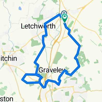
Thumbs Up Barton
A cycling route starting in Baldock, England, United Kingdom.
Overview
About this route
All routes OS map verified Bridleways, Byways, and Restricted Byways. Ordnance Survey Map required: 193 - Luton & Stevenage
- -:--
- Duration
- 53.8 km
- Distance
- 361 m
- Ascent
- 362 m
- Descent
- ---
- Avg. speed
- ---
- Avg. speed
Route photos
Route quality
Waytypes & surfaces along the route
Waytypes
Cycleway
19.9 km
(37 %)
Road
12.8 km
(24 %)
Surfaces
Paved
4.8 km
(9 %)
Unpaved
14.2 km
(26 %)
Ground
6.6 km
(12 %)
Gravel
5.4 km
(10 %)
Continue with Bikemap
Use, edit, or download this cycling route
You would like to ride Thumbs Up Barton or customize it for your own trip? Here is what you can do with this Bikemap route:
Free features
- Save this route as favorite or in collections
- Copy & plan your own version of this route
- Sync your route with Garmin or Wahoo
Premium features
Free trial for 3 days, or one-time payment. More about Bikemap Premium.
- Navigate this route on iOS & Android
- Export a GPX / KML file of this route
- Create your custom printout (try it for free)
- Download this route for offline navigation
Discover more Premium features.
Get Bikemap PremiumFrom our community
Other popular routes starting in Baldock
- West Cam
- Distance
- 129.2 km
- Ascent
- 246 m
- Descent
- 246 m
- Location
- Baldock, England, United Kingdom
- Hatley Wood Spaghetti
- Distance
- 64.8 km
- Ascent
- 242 m
- Descent
- 244 m
- Location
- Baldock, England, United Kingdom
- Mighty Meander
- Distance
- 173.8 km
- Ascent
- 460 m
- Descent
- 460 m
- Location
- Baldock, England, United Kingdom
- Thunder Ridge
- Distance
- 76.9 km
- Ascent
- 402 m
- Descent
- 401 m
- Location
- Baldock, England, United Kingdom
- Northern Woods
- Distance
- 60.4 km
- Ascent
- 270 m
- Descent
- 271 m
- Location
- Baldock, England, United Kingdom
- Wiggy
- Distance
- 48.3 km
- Ascent
- 334 m
- Descent
- 334 m
- Location
- Baldock, England, United Kingdom
- Cross-Potter
- Distance
- 52.3 km
- Ascent
- 159 m
- Descent
- 161 m
- Location
- Baldock, England, United Kingdom
- Halo Reach
- Distance
- 122.5 km
- Ascent
- 158 m
- Descent
- 158 m
- Location
- Baldock, England, United Kingdom
Open it in the app