

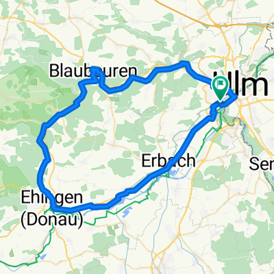
Ulm - Blaubeuren (Blautopf) - Ulm
A cycling route starting in Ulm, Baden-Württemberg, Germany.
Overview
About this route
Von Ulmer Metzgerturm zum Blautopf. Radweg durchs Blautal. Zurück über Sonderbucher Steige und Wippingen.
- -:--
- Duration
- 41.2 km
- Distance
- 372 m
- Ascent
- 373 m
- Descent
- ---
- Avg. speed
- ---
- Max. altitude
Route quality
Waytypes & surfaces along the route
Waytypes
Path
13 km
(32 %)
Quiet road
8.5 km
(21 %)
Surfaces
Paved
36.3 km
(88 %)
Unpaved
0 km
(<1 %)
Asphalt
35.6 km
(87 %)
Wood
0.6 km
(1 %)
Continue with Bikemap
Use, edit, or download this cycling route
You would like to ride Ulm - Blaubeuren (Blautopf) - Ulm or customize it for your own trip? Here is what you can do with this Bikemap route:
Free features
- Save this route as favorite or in collections
- Copy & plan your own version of this route
- Sync your route with Garmin or Wahoo
Premium features
Free trial for 3 days, or one-time payment. More about Bikemap Premium.
- Navigate this route on iOS & Android
- Export a GPX / KML file of this route
- Create your custom printout (try it for free)
- Download this route for offline navigation
Discover more Premium features.
Get Bikemap PremiumFrom our community
Other popular routes starting in Ulm
 Blaustein-Örlingen-Donau
- Distance
- 28.9 km
- Ascent
- 222 m
- Descent
- 219 m
- Location
- Ulm, Baden-Württemberg, Germany
 Ulm - Blaubeuren - Ehingen - Erbach - Ulm
- Distance
- 68.1 km
- Ascent
- 266 m
- Descent
- 266 m
- Location
- Ulm, Baden-Württemberg, Germany
 Ulm-Seissen-Ulm
- Distance
- 62.6 km
- Ascent
- 882 m
- Descent
- 859 m
- Location
- Ulm, Baden-Württemberg, Germany
 Ulm-Donau-Bodensee-Iller
- Distance
- 405.6 km
- Ascent
- 754 m
- Descent
- 753 m
- Location
- Ulm, Baden-Württemberg, Germany
 Trainingsfahrt im Ulmer Norden
- Distance
- 35.6 km
- Ascent
- 337 m
- Descent
- 340 m
- Location
- Ulm, Baden-Württemberg, Germany
 Kleine Runde von Ulm ins Oberschwäbische
- Distance
- 86.2 km
- Ascent
- 524 m
- Descent
- 513 m
- Location
- Ulm, Baden-Württemberg, Germany
 Hills @Blautal
- Distance
- 48.9 km
- Ascent
- 540 m
- Descent
- 540 m
- Location
- Ulm, Baden-Württemberg, Germany
 25 km Trainingsroute Ulm
- Distance
- 25.1 km
- Ascent
- 90 m
- Descent
- 87 m
- Location
- Ulm, Baden-Württemberg, Germany
Open it in the app