

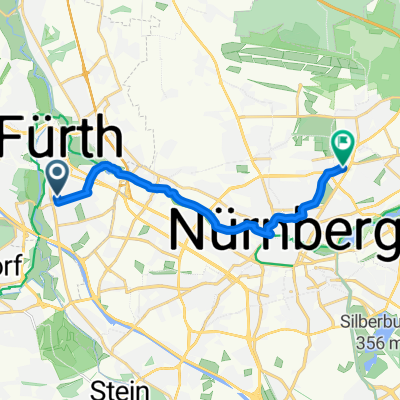
Entlang der Pegnitz
A cycling route starting in Fürth, Bavaria, Germany.
Overview
About this route
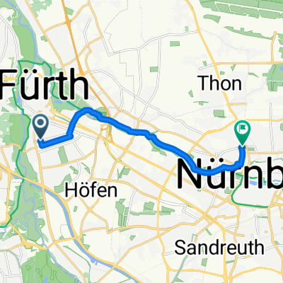
Bicycle route from Fürth, Vacher Str., to the Lederer Biergarten in Nuremberg. The route is almost entirely a bicycle and pedestrian path without cars. On nice days, the bike path is heavily frequented.
- -:--
- Duration
- 7.4 km
- Distance
- 41 m
- Ascent
- 20 m
- Descent
- ---
- Avg. speed
- 309 m
- Max. altitude
Route quality
Waytypes & surfaces along the route
Waytypes
Path
6.8 km
(92 %)
Pedestrian area
0.3 km
(4 %)
Surfaces
Paved
7.4 km
(100 %)
Asphalt
7.4 km
(100 %)
Continue with Bikemap
Use, edit, or download this cycling route
You would like to ride Entlang der Pegnitz or customize it for your own trip? Here is what you can do with this Bikemap route:
Free features
- Save this route as favorite or in collections
- Copy & plan your own version of this route
- Sync your route with Garmin or Wahoo
Premium features
Free trial for 3 days, or one-time payment. More about Bikemap Premium.
- Navigate this route on iOS & Android
- Export a GPX / KML file of this route
- Create your custom printout (try it for free)
- Download this route for offline navigation
Discover more Premium features.
Get Bikemap PremiumFrom our community
Other popular routes starting in Fürth
 Stadeln - gemütliche gemischte Dreistädtetour
- Distance
- 19.1 km
- Ascent
- 142 m
- Descent
- 140 m
- Location
- Fürth, Bavaria, Germany
 St2242 nach Friedrich-Ebert-Platz
- Distance
- 8.4 km
- Ascent
- 60 m
- Descent
- 39 m
- Location
- Fürth, Bavaria, Germany
 Teichtour ab Fürth
- Distance
- 85 km
- Ascent
- 394 m
- Descent
- 435 m
- Location
- Fürth, Bavaria, Germany
 Klosterbrauerei Weißenohe
- Distance
- 67.2 km
- Ascent
- 526 m
- Descent
- 506 m
- Location
- Fürth, Bavaria, Germany
 St2242 nach Lilienstraße
- Distance
- 24.6 km
- Ascent
- 183 m
- Descent
- 153 m
- Location
- Fürth, Bavaria, Germany
 Von Fürth bis Lichtenau 51 Km
- Distance
- 52.4 km
- Ascent
- 690 m
- Descent
- 594 m
- Location
- Fürth, Bavaria, Germany
 Stadeln Cadolzburg Runweg
- Distance
- 49.8 km
- Ascent
- 307 m
- Descent
- 309 m
- Location
- Fürth, Bavaria, Germany
 Zu stay 2
- Distance
- 11.4 km
- Ascent
- 81 m
- Descent
- 60 m
- Location
- Fürth, Bavaria, Germany
Open it in the app