
Pic de cabres y sendas
A cycling route starting in Moncofa, Valencia, Spain.
Overview
About this route
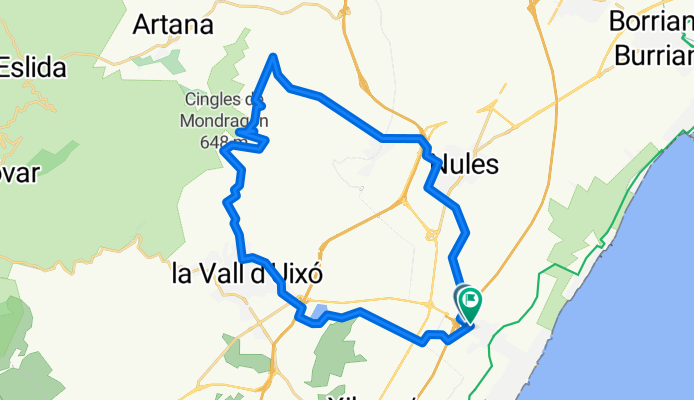
This route includes a couple of trails that start at 'Pic de Cabres' and end in Vall d'uixó, these are trails with some technical sections, but there’s no major problem with getting off the bike and going through them on foot. Generally, it's worth losing a bit of time because the trails are spectacular and the views... We leave Moncofa looking for the service road of the highway and take the 'Cami Vilavella' to Nules, which we go around to get to Villavieja via paths. Once in Villavieja, the ascent begins by the sports complex, we take a little trail and connect with the 'Aigües Vives' track towards 'Pic de Cabres'. Once we’re below the peak, the path begins, which runs along a slope and connects with the 'Senda Caçadors' which leads to a track that goes up to a spring. We go up a bit on the track and connect through a road blocked by a chain, we pass and that’s where the last trail begins that will take us to Vall d'uixó. We cross Vall d'uixó and search for the last stretch of paths and tracks that will take us back to Moncofa. If you plan to come by car, you can start in Villavieja and from Vall d'uixó connect with the track 'La Murta', which leads directly to Villavieja.
- 2 h 55 min
- Duration
- 33.7 km
- Distance
- 1,366 m
- Ascent
- 1,378 m
- Descent
- 11.5 km/h
- Avg. speed
- ---
- Max. altitude
Continue with Bikemap
Use, edit, or download this cycling route
You would like to ride Pic de cabres y sendas or customize it for your own trip? Here is what you can do with this Bikemap route:
Free features
- Save this route as favorite or in collections
- Copy & plan your own version of this route
- Sync your route with Garmin or Wahoo
Premium features
Free trial for 3 days, or one-time payment. More about Bikemap Premium.
- Navigate this route on iOS & Android
- Export a GPX / KML file of this route
- Create your custom printout (try it for free)
- Download this route for offline navigation
Discover more Premium features.
Get Bikemap PremiumFrom our community
Other popular routes starting in Moncofa
 cinco puertos
- Distance
- 116.5 km
- Ascent
- 1,588 m
- Descent
- 1,587 m
- Location
- Moncofa, Valencia, Spain
 Ruta Ultra Espadán.
- Distance
- 201.2 km
- Ascent
- 3,007 m
- Descent
- 3,006 m
- Location
- Moncofa, Valencia, Spain
 Subida al Garbí y vuelta por Torres Torres
- Distance
- 91 km
- Ascent
- 661 m
- Descent
- 661 m
- Location
- Moncofa, Valencia, Spain
 MEDIO IRON MAN COFASUB 2013
- Distance
- 92.8 km
- Ascent
- 814 m
- Descent
- 815 m
- Location
- Moncofa, Valencia, Spain
 Moncofa-Matet-Moncofa
- Distance
- 115.9 km
- Ascent
- 1,859 m
- Descent
- 1,859 m
- Location
- Moncofa, Valencia, Spain
 Moncofa - trialeras de la punta
- Distance
- 21.3 km
- Ascent
- 427 m
- Descent
- 454 m
- Location
- Moncofa, Valencia, Spain
 Moncofa-Matet-Moncofa
- Distance
- 115.9 km
- Ascent
- 1,913 m
- Descent
- 1,913 m
- Location
- Moncofa, Valencia, Spain
 Pic de cabres y sendas
- Distance
- 33.7 km
- Ascent
- 1,366 m
- Descent
- 1,378 m
- Location
- Moncofa, Valencia, Spain
Open it in the app