

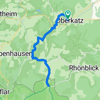
Helmershausen/Rhönblick - Schwarzes Moor
A cycling route starting in Oberkatz, Thuringia, Germany.
Overview
About this route
Loop route
- -:--
- Duration
- 39.5 km
- Distance
- 610 m
- Ascent
- 609 m
- Descent
- ---
- Avg. speed
- ---
- Max. altitude
Route quality
Waytypes & surfaces along the route
Waytypes
Road
14.2 km
(36 %)
Track
11.8 km
(30 %)
Surfaces
Paved
16.6 km
(42 %)
Unpaved
7.1 km
(18 %)
Asphalt
14.2 km
(36 %)
Gravel
3.2 km
(8 %)
Route highlights
Points of interest along the route
Point of interest after 22.2 km
Schwarzes Moor - Kneipe
Continue with Bikemap
Use, edit, or download this cycling route
You would like to ride Helmershausen/Rhönblick - Schwarzes Moor or customize it for your own trip? Here is what you can do with this Bikemap route:
Free features
- Save this route as favorite or in collections
- Copy & plan your own version of this route
- Sync your route with Garmin or Wahoo
Premium features
Free trial for 3 days, or one-time payment. More about Bikemap Premium.
- Navigate this route on iOS & Android
- Export a GPX / KML file of this route
- Create your custom printout (try it for free)
- Download this route for offline navigation
Discover more Premium features.
Get Bikemap PremiumFrom our community
Other popular routes starting in Oberkatz
 RUNDWEG
- Distance
- 10.8 km
- Ascent
- 251 m
- Descent
- 251 m
- Location
- Oberkatz, Thuringia, Germany
 Gemütliche Route in Rhönblick
- Distance
- 41.2 km
- Ascent
- 547 m
- Descent
- 547 m
- Location
- Oberkatz, Thuringia, Germany
 day 21 alt
- Distance
- 103.3 km
- Ascent
- 727 m
- Descent
- 740 m
- Location
- Oberkatz, Thuringia, Germany
 geba 2
- Distance
- 19.6 km
- Ascent
- 135 m
- Descent
- 511 m
- Location
- Oberkatz, Thuringia, Germany
 Helmershausen/Rhönblick - Schwarzes Moor
- Distance
- 39.5 km
- Ascent
- 610 m
- Descent
- 609 m
- Location
- Oberkatz, Thuringia, Germany
 Oberkatz - Hohe Löhr - Hohe Geba
- Distance
- 14.2 km
- Ascent
- 345 m
- Descent
- 345 m
- Location
- Oberkatz, Thuringia, Germany
 Äå!◊? nach Äå!◊?
- Distance
- 38.6 km
- Ascent
- 409 m
- Descent
- 409 m
- Location
- Oberkatz, Thuringia, Germany
 Unterkätzer Straße, Kaltennordheim nach Unterkätzer Straße, Kaltennordheim
- Distance
- 23.3 km
- Ascent
- 355 m
- Descent
- 354 m
- Location
- Oberkatz, Thuringia, Germany
Open it in the app