

Nationalpark Bike-Marathon - Start in S'charl
A cycling route starting in Scuol, Grisons, Switzerland.
Overview
About this route
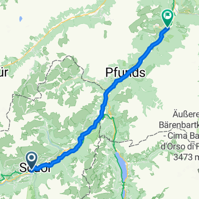
Start in S'charl
Stage 1
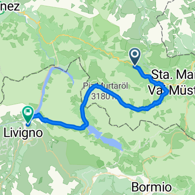
S'charl - Livorno
Stage 2
Livorno - Zernez
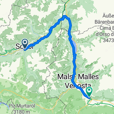
Stage 3
Zernez - S'charl
- -:--
- Duration
- 132.9 km
- Distance
- 3,165 m
- Ascent
- 3,165 m
- Descent
- ---
- Avg. speed
- ---
- Max. altitude

Continue with Bikemap
Use, edit, or download this cycling route
You would like to ride Nationalpark Bike-Marathon - Start in S'charl or customize it for your own trip? Here is what you can do with this Bikemap route:
Free features
- Save this route as favorite or in collections
- Copy & plan your own version of this route
- Split it into stages to create a multi-day tour
- Sync your route with Garmin or Wahoo
Premium features
Free trial for 3 days, or one-time payment. More about Bikemap Premium.
- Navigate this route on iOS & Android
- Export a GPX / KML file of this route
- Create your custom printout (try it for free)
- Download this route for offline navigation
Discover more Premium features.
Get Bikemap PremiumFrom our community
Other popular routes starting in Scuol
 Brentschpark C, Scuol nach Stradun 327, Scuol
- Distance
- 35.8 km
- Ascent
- 1,029 m
- Descent
- 1,027 m
- Location
- Scuol, Grisons, Switzerland
 444-02: Nationalpark Bike-Tour. Etappe 2 Tschierv - Livigno
- Distance
- 39.6 km
- Ascent
- 1,467 m
- Descent
- 1,324 m
- Location
- Scuol, Grisons, Switzerland
 444-01: Nationalpark Bike-Tour. Etappe 1 Scuol - Tschierv
- Distance
- 30.9 km
- Ascent
- 1,360 m
- Descent
- 979 m
- Location
- Scuol, Grisons, Switzerland
 Alpencross 2010 | Etappe 3
- Distance
- 73.7 km
- Ascent
- 2,522 m
- Descent
- 1,811 m
- Location
- Scuol, Grisons, Switzerland
 Davos - Prad am Stilfserjoch
- Distance
- 59.8 km
- Ascent
- 1,577 m
- Descent
- 1,929 m
- Location
- Scuol, Grisons, Switzerland
 Uina Schlucht (Engadin)
- Distance
- 84.5 km
- Ascent
- 2,509 m
- Descent
- 2,509 m
- Location
- Scuol, Grisons, Switzerland
 Jakobsweg Graubünden, Scuol nach Vichava, Ftan
- Distance
- 40.8 km
- Ascent
- 1,495 m
- Descent
- 1,318 m
- Location
- Scuol, Grisons, Switzerland
 Scuol nach Ried im Oberinntal (Innradweg)
- Distance
- 46.9 km
- Ascent
- 1,107 m
- Descent
- 1,492 m
- Location
- Scuol, Grisons, Switzerland
Open it in the app