

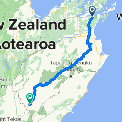
Cycle NZ (Day 17)
A cycling route starting in Picton, Marlborough, New Zealand.
Overview
About this route
- -:--
- Duration
- 163.9 km
- Distance
- 730 m
- Ascent
- 736 m
- Descent
- ---
- Avg. speed
- ---
- Max. altitude

Route quality
Waytypes & surfaces along the route
Waytypes
Quiet road
11.5 km
(7 %)
Undefined
152.4 km
(93 %)
Surfaces
Paved
152.4 km
(93 %)
Unpaved
11.5 km
(7 %)
Asphalt
152.4 km
(93 %)
Unpaved (undefined)
11.5 km
(7 %)
Route highlights
Points of interest along the route
Accommodation after 0 km
rest day 15
Accommodation after 0.2 km
rest day 12
Accommodation after 0.2 km
rest day 16
Accommodation after 0.2 km
Rest day 14
Accommodation after 0.2 km
Rest day 13
Accommodation after 163.9 km
Rest day 17
Accommodation after 163.9 km
Rest day 20
Accommodation after 163.9 km
Finally Done
Accommodation after 163.9 km
rest day 19
Drinking water after 163.9 km
Ferry needs to be booked
Accommodation after 163.9 km
Rest day 18
Continue with Bikemap
Use, edit, or download this cycling route
You would like to ride Cycle NZ (Day 17) or customize it for your own trip? Here is what you can do with this Bikemap route:
Free features
- Save this route as favorite or in collections
- Copy & plan your own version of this route
- Split it into stages to create a multi-day tour
- Sync your route with Garmin or Wahoo
Premium features
Free trial for 3 days, or one-time payment. More about Bikemap Premium.
- Navigate this route on iOS & Android
- Export a GPX / KML file of this route
- Create your custom printout (try it for free)
- Download this route for offline navigation
Discover more Premium features.
Get Bikemap PremiumFrom our community
Other popular routes starting in Picton
 Picton - Motueka
- Distance
- 178 km
- Ascent
- 759 m
- Descent
- 127 m
- Location
- Picton, Marlborough, New Zealand
 Locycle - NZ South Island
- Distance
- 1,776.2 km
- Ascent
- 3,288 m
- Descent
- 2,877 m
- Location
- Picton, Marlborough, New Zealand
 Neuseeland Südinsel
- Distance
- 195 km
- Ascent
- 4,029 m
- Descent
- 3,270 m
- Location
- Picton, Marlborough, New Zealand
 1–15 Dublin Street, Picton to 267 Anakiwa Road, Anakiwa
- Distance
- 23.7 km
- Ascent
- 752 m
- Descent
- 757 m
- Location
- Picton, Marlborough, New Zealand
 Cycle NZ South Island Track 01
- Distance
- 113.4 km
- Ascent
- 1,028 m
- Descent
- 1,025 m
- Location
- Picton, Marlborough, New Zealand
 Alternative South Island traverse
- Distance
- 1,608.8 km
- Ascent
- 3,107 m
- Descent
- 3,100 m
- Location
- Picton, Marlborough, New Zealand
 South Island traverse
- Distance
- 1,636.6 km
- Ascent
- 3,281 m
- Descent
- 3,266 m
- Location
- Picton, Marlborough, New Zealand
 South island
- Distance
- 1,488.7 km
- Ascent
- 3,626 m
- Descent
- 3,623 m
- Location
- Picton, Marlborough, New Zealand
Open it in the app