
Blanka jede do Orange - opraveno dle SK a přizpůsobeno lepší trase
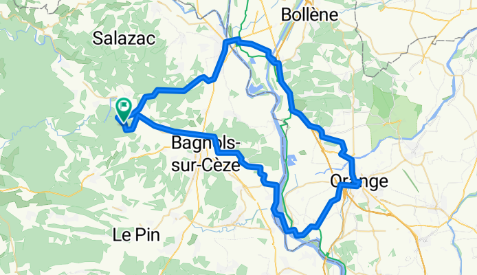
A cycling route starting in Sabran, Occitanie, France.
Overview
About this route
2
- -:--
- Duration
- 80.9 km
- Distance
- 344 m
- Ascent
- 344 m
- Descent
- ---
- Avg. speed
- ---
- Max. altitude
bondo.cz
created this 15 years ago
Route quality
Waytypes & surfaces along the route
Waytypes
Quiet road
28.3 km
35 %
Road
22.6 km
28 %
Surfaces
Paved
41.2 km
(51 %)
Asphalt
39.6 km
49 %
Paved (undefined)
0.8 km
1 %
Continue with Bikemap
Use, edit, or download this cycling route
You would like to ride Blanka jede do Orange - opraveno dle SK a přizpůsobeno lepší trase or customize it for your own trip? Here is what you can do with this Bikemap route:
Free features
- Save this route as favorite or in collections
- Copy & plan your own version of this route
- Split it into stages to create a multi-day tour
- Sync your route with Garmin or Wahoo
Premium features
Free trial for 3 days, or one-time payment. More about Bikemap Premium.
- Navigate this route on iOS & Android
- Export a GPX / KML file of this route
- Create your custom printout (try it for free)
- Download this route for offline navigation
Discover more Premium features.
Get Bikemap PremiumFrom our community
Other popular routes starting in Sabran
- De Le Molinas, Saint-André-d'Olérargues à Chemin Montplaisir 197, Tulette0
- 82 km
- 636 m
- 660 m
- Sabran, Occitanie, France
- Rue d'Apparan 21, Saint-Michel-d'Euzet to Rue Victor Hugo 26, Saintes-Maries-de-la-Mer0
- 110.3 km
- 559 m
- 647 m
- Sabran, Occitanie, France
- Blanka jede do Orange - opraveno dle SK a přizpůsobeno lepší trase2
- 80.9 km
- 344 m
- 344 m
- Sabran, Occitanie, France
- Rue d'Apparan 21, Saint-Michel-d'Euzet to Rue Mal de Thoiras 1, Saint-Jean-du-Gard0
- 76.5 km
- 1,419 m
- 1,319 m
- Sabran, Occitanie, France


Open it in the app