

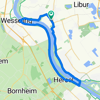
Spicher Straße 24, Niederkassel nach Otto-Hahn-Straße 14, Niederkassel
A cycling route starting in Niederkassel, North Rhine-Westphalia, Germany.
Overview
About this route
- 1 h 25 min
- Duration
- 19.1 km
- Distance
- 135 m
- Ascent
- 131 m
- Descent
- 13.5 km/h
- Avg. speed
- ---
- Max. altitude

Route quality
Waytypes & surfaces along the route
Waytypes
Track
7.8 km
(41 %)
Path
4.6 km
(24 %)
Surfaces
Paved
17.2 km
(90 %)
Asphalt
17 km
(89 %)
Concrete
0.2 km
(1 %)
Undefined
1.9 km
(10 %)
Continue with Bikemap
Use, edit, or download this cycling route
You would like to ride Spicher Straße 24, Niederkassel nach Otto-Hahn-Straße 14, Niederkassel or customize it for your own trip? Here is what you can do with this Bikemap route:
Free features
- Save this route as favorite or in collections
- Copy & plan your own version of this route
- Sync your route with Garmin or Wahoo
Premium features
Free trial for 3 days, or one-time payment. More about Bikemap Premium.
- Navigate this route on iOS & Android
- Export a GPX / KML file of this route
- Create your custom printout (try it for free)
- Download this route for offline navigation
Discover more Premium features.
Get Bikemap PremiumFrom our community
Other popular routes starting in Niederkassel
 EDT-West - Train - Nideggen
- Distance
- 133.8 km
- Ascent
- 763 m
- Descent
- 763 m
- Location
- Niederkassel, North Rhine-Westphalia, Germany
 Fähr-Runde um Niederkassel
- Distance
- 21.9 km
- Ascent
- 48 m
- Descent
- 47 m
- Location
- Niederkassel, North Rhine-Westphalia, Germany
 Lülsdorfer RTF, 111 Km-Strecke
- Distance
- 110.7 km
- Ascent
- 588 m
- Descent
- 590 m
- Location
- Niederkassel, North Rhine-Westphalia, Germany
 Ausfahrt durch Niederkassel
- Distance
- 23.8 km
- Ascent
- 35 m
- Descent
- 39 m
- Location
- Niederkassel, North Rhine-Westphalia, Germany
 Rhein/Bröl/Sieg
- Distance
- 82.5 km
- Ascent
- 932 m
- Descent
- 925 m
- Location
- Niederkassel, North Rhine-Westphalia, Germany
 von Lülsdorf rund um den Flughafen
- Distance
- 42.7 km
- Ascent
- 142 m
- Descent
- 142 m
- Location
- Niederkassel, North Rhine-Westphalia, Germany
 Flughafenrunde über Pfaffen Brauerei :-)
- Distance
- 47.9 km
- Ascent
- 240 m
- Descent
- 241 m
- Location
- Niederkassel, North Rhine-Westphalia, Germany
 Siebengebirge 70km
- Distance
- 70.5 km
- Ascent
- 738 m
- Descent
- 737 m
- Location
- Niederkassel, North Rhine-Westphalia, Germany
Open it in the app