

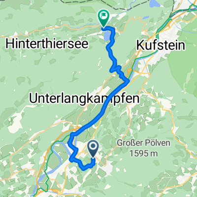
Kitzbühel-Going
A cycling route starting in Bad Häring, Tyrol, Austria.
Overview
About this route
über Brixental nach Kirchberg, Kitzbühel, Going, Elmau Söll zurück
- -:--
- Duration
- 71.9 km
- Distance
- 638 m
- Ascent
- 614 m
- Descent
- ---
- Avg. speed
- ---
- Max. altitude

Route quality
Waytypes & surfaces along the route
Waytypes
Quiet road
42.4 km
(59 %)
Road
8.6 km
(12 %)
Surfaces
Paved
60.4 km
(84 %)
Unpaved
1.4 km
(2 %)
Asphalt
58.9 km
(82 %)
Paved (undefined)
1.4 km
(2 %)
Continue with Bikemap
Use, edit, or download this cycling route
You would like to ride Kitzbühel-Going or customize it for your own trip? Here is what you can do with this Bikemap route:
Free features
- Save this route as favorite or in collections
- Copy & plan your own version of this route
- Sync your route with Garmin or Wahoo
Premium features
Free trial for 3 days, or one-time payment. More about Bikemap Premium.
- Navigate this route on iOS & Android
- Export a GPX / KML file of this route
- Create your custom printout (try it for free)
- Download this route for offline navigation
Discover more Premium features.
Get Bikemap PremiumFrom our community
Other popular routes starting in Bad Häring
 Bad Häring - Thiersee
- Distance
- 16 km
- Ascent
- 366 m
- Descent
- 339 m
- Location
- Bad Häring, Tyrol, Austria
 Weinbergerhaus / Brentenjoch Trail
- Distance
- 42.9 km
- Ascent
- 989 m
- Descent
- 989 m
- Location
- Bad Häring, Tyrol, Austria
 Buzler JW Stans bis Fritzens-Wattens
- Distance
- 54 km
- Ascent
- 319 m
- Descent
- 325 m
- Location
- Bad Häring, Tyrol, Austria
 B.H. - Eiberg - Hintersteinersee - Söll - B.H.
- Distance
- 40.8 km
- Ascent
- 858 m
- Descent
- 858 m
- Location
- Bad Häring, Tyrol, Austria
 12. Etappe der Italientour
- Distance
- 182.7 km
- Ascent
- 667 m
- Descent
- 934 m
- Location
- Bad Häring, Tyrol, Austria
 Bad Häring - Buchacker
- Distance
- 32.6 km
- Ascent
- 1,004 m
- Descent
- 1,007 m
- Location
- Bad Häring, Tyrol, Austria
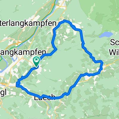 Pölven Radrunde
- Distance
- 29.6 km
- Ascent
- 488 m
- Descent
- 490 m
- Location
- Bad Häring, Tyrol, Austria
 Bad Häring - Rattenberg - Kramsach - Museum Tiroler Bauernhöfe (mit Kirchtag)
- Distance
- 58.9 km
- Ascent
- 452 m
- Descent
- 452 m
- Location
- Bad Häring, Tyrol, Austria
Open it in the app