

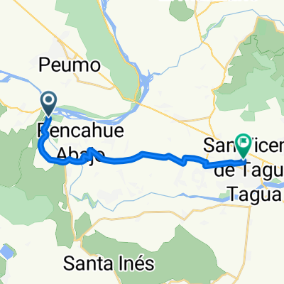
De Los Paltos 752, Peumo a Calle Principal, San Vicente
A cycling route starting in San Vicente, O'Higgins Region, Chile.
Overview
About this route
- 58 min
- Duration
- 12.9 km
- Distance
- 124 m
- Ascent
- 120 m
- Descent
- 13.4 km/h
- Avg. speed
- ---
- Max. altitude

Route quality
Waytypes & surfaces along the route
Waytypes
Quiet road
5.9 km
(46 %)
Path
2.5 km
(19 %)
Surfaces
Paved
6.1 km
(47 %)
Unpaved
2.1 km
(16 %)
Paved (undefined)
4.8 km
(37 %)
Ground
1.7 km
(13 %)
Continue with Bikemap
Use, edit, or download this cycling route
You would like to ride De Los Paltos 752, Peumo a Calle Principal, San Vicente or customize it for your own trip? Here is what you can do with this Bikemap route:
Free features
- Save this route as favorite or in collections
- Copy & plan your own version of this route
- Sync your route with Garmin or Wahoo
Premium features
Free trial for 3 days, or one-time payment. More about Bikemap Premium.
- Navigate this route on iOS & Android
- Export a GPX / KML file of this route
- Create your custom printout (try it for free)
- Download this route for offline navigation
Discover more Premium features.
Get Bikemap PremiumFrom our community
Other popular routes starting in San Vicente
 Ruta H-774, Peumo a Walker Martínez, Peumo
- Distance
- 6.4 km
- Ascent
- 23 m
- Descent
- 6 m
- Location
- San Vicente, O'Higgins Region, Chile
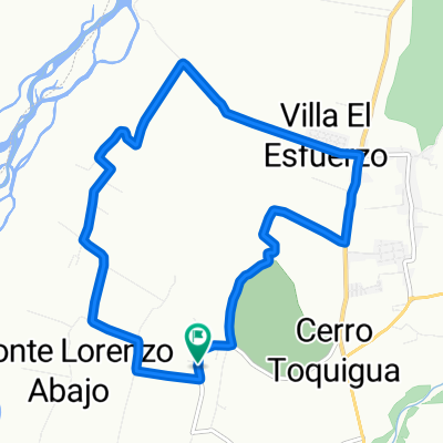 Cerro Toquihua Monte Lorenzo
- Distance
- 11.7 km
- Ascent
- 154 m
- Descent
- 152 m
- Location
- San Vicente, O'Higgins Region, Chile
 De H-588, San Vicente a H-588, San Vicente
- Distance
- 25.7 km
- Ascent
- 346 m
- Descent
- 383 m
- Location
- San Vicente, O'Higgins Region, Chile
 De Camino Alto del Huesillo, San Vicente de Tagua Tagua a Camino Alto del Huesillo, San Vicente de Tagua Tagua
- Distance
- 11.7 km
- Ascent
- 373 m
- Descent
- 375 m
- Location
- San Vicente, O'Higgins Region, Chile
 De H-50, Quinta de Tilcoco a H-574, Quinta de Tilcoco
- Distance
- 106.8 km
- Ascent
- 449 m
- Descent
- 454 m
- Location
- San Vicente, O'Higgins Region, Chile
 parquímetros
- Distance
- 14.1 km
- Ascent
- 20 m
- Descent
- 22 m
- Location
- San Vicente, O'Higgins Region, Chile
 San Vicente - San José de Marchihue - Los Maitenes - Cruce Ruta 90 (Marchihue), San Vicente to Michimalongo 195–315, San Vicente
- Distance
- 12.9 km
- Ascent
- 40 m
- Descent
- 12 m
- Location
- San Vicente, O'Higgins Region, Chile
 De H-50 035, Quinta de Tilcoco a H-50, Quinta de Tilcoco
- Distance
- 23.1 km
- Ascent
- 213 m
- Descent
- 222 m
- Location
- San Vicente, O'Higgins Region, Chile
Open it in the app