
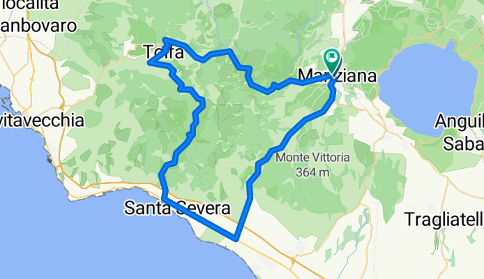
Manziana-Sasso-Santa Severa-Tolfa- Rota- Manziana
A cycling route starting in Manziana, Lazio, Italy.
Overview
About this route
71 km
23.1 k/h di media
71,3 km/h max
3h 28 min
153 battiti di media
2660 kal
- -:--
- Duration
- 72.3 km
- Distance
- 882 m
- Ascent
- 884 m
- Descent
- ---
- Avg. speed
- ---
- Max. altitude
Route quality
Waytypes & surfaces along the route
Waytypes
Busy road
68.8 km
(95 %)
Quiet road
1.4 km
(2 %)
Surfaces
Paved
68.7 km
(95 %)
Unpaved
0.2 km
(<1 %)
Asphalt
68.7 km
(95 %)
Unpaved (undefined)
0.2 km
(<1 %)
Continue with Bikemap
Use, edit, or download this cycling route
You would like to ride Manziana-Sasso-Santa Severa-Tolfa- Rota- Manziana or customize it for your own trip? Here is what you can do with this Bikemap route:
Free features
- Save this route as favorite or in collections
- Copy & plan your own version of this route
- Sync your route with Garmin or Wahoo
Premium features
Free trial for 3 days, or one-time payment. More about Bikemap Premium.
- Navigate this route on iOS & Android
- Export a GPX / KML file of this route
- Create your custom printout (try it for free)
- Download this route for offline navigation
Discover more Premium features.
Get Bikemap PremiumFrom our community
Other popular routes starting in Manziana
 Uscita Caldare e Cascate S. Giuliano
- Distance
- 32.6 km
- Ascent
- 359 m
- Descent
- 347 m
- Location
- Manziana, Lazio, Italy
 Manziana Bosco San Liberato
- Distance
- 18.7 km
- Ascent
- 357 m
- Descent
- 356 m
- Location
- Manziana, Lazio, Italy
 Randonèe delle acque termali 2019 - Manziana medio
- Distance
- 49.1 km
- Ascent
- 517 m
- Descent
- 517 m
- Location
- Manziana, Lazio, Italy
 manziana tarquinia manziana
- Distance
- 114.7 km
- Ascent
- 726 m
- Descent
- 716 m
- Location
- Manziana, Lazio, Italy
 Bosco Manziana 10.7 KM
- Distance
- 10.8 km
- Ascent
- 110 m
- Descent
- 110 m
- Location
- Manziana, Lazio, Italy
 2022.06.08 - Anello Manziana Oriolo Vejano Cascate di Diosilla Manziana
- Distance
- 43.1 km
- Ascent
- 838 m
- Descent
- 850 m
- Location
- Manziana, Lazio, Italy
 Manziana-Sasso-Santa Severa-Tolfa- Rota- Manziana
- Distance
- 72.3 km
- Ascent
- 882 m
- Descent
- 884 m
- Location
- Manziana, Lazio, Italy
 Ipogeo Manziana 2 koom – Civitella Cesi Itinerario ad anello da Manziana - Canale Monterano
- Distance
- 65.3 km
- Ascent
- 1,862 m
- Descent
- 1,863 m
- Location
- Manziana, Lazio, Italy
Open it in the app