- 39 km
- 583 m
- 585 m
- BuƱol, Valencia, Spain
BuƱol
A cycling route starting in BuƱol, Valencia, Spain.
Overview
About this route
This route starts in BuƱol, the first and last parts are on lightly trafficked roads. After a few kilometers on asphalt, we turn right onto a path to begin ascending towards the antennas on top of the mountain, then continue progressing to the Moratilla farmhouse. It is not at all advisable to descend from the Moratilla farmhouse, as it is a very narrow trail that must be walked, descending to the bottom of the ravine, and then you have to go through the canyons with the bike on your shoulder to return to the path. It is highly recommended to turn back, retrace the last kilometers, and return via the circular variant of the route.
- -:--
- Duration
- 46.5 km
- Distance
- 859 m
- Ascent
- 750 m
- Descent
- ---
- Avg. speed
- ---
- Max. altitude
created this 15 years ago
Continue with Bikemap
Use, edit, or download this cycling route
You would like to ride BuƱol or customize it for your own trip? Here is what you can do with this Bikemap route:
Free features
- Save this route as favorite or in collections
- Copy & plan your own version of this route
- Sync your route with Garmin or Wahoo
Premium features
Free trial for 3 days, or one-time payment. More about Bikemap Premium.
- Navigate this route on iOS & Android
- Export a GPX / KML file of this route
- Create your custom printout (try it for free)
- Download this route for offline navigation
Discover more Premium features.
Get Bikemap PremiumFrom our community
Other popular routes starting in BuƱol
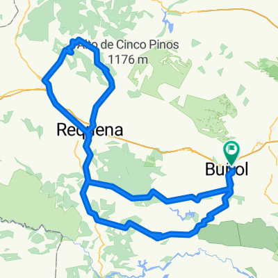
- Buñol - Miravalencia - Ferrajón - La Ceja
- Ruta relajada en BuƱol
- 26.4 km
- 597 m
- 598 m
- BuƱol, Valencia, Spain
- 1. Etappe Valencia-Albacete A
- 160.6 km
- 1,079 m
- 803 m
- BuƱol, Valencia, Spain
- ruta montaƱa cerca de valencia ciudad
- 175.2 km
- 1,642 m
- 1,632 m
- BuƱol, Valencia, Spain
- BuƱol
- 46.5 km
- 859 m
- 750 m
- BuƱol, Valencia, Spain
- Carretera Estación 2, BuƱol ć¾ć§Carrer de l'Almirall Cadarso 7, ValĆØncia
- 50.2 km
- 106 m
- 558 m
- BuƱol, Valencia, Spain
- BuƱol - Utiel
- 61.4 km
- 838 m
- 430 m
- BuƱol, Valencia, Spain
- Ventamina-Sierra Chiva - Barrancos
- 36.8 km
- 950 m
- 950 m
- BuƱol, Valencia, Spain
Open it in the app


