
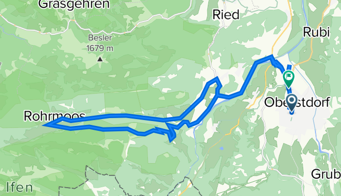
Oberstdorf - Rohrmoos
A cycling route starting in Oberstdorf, Bavaria, Germany.
Overview
About this route
- 1 h 25 min
- Duration
- 25.9 km
- Distance
- 449 m
- Ascent
- 513 m
- Descent
- 18.2 km/h
- Avg. speed
- ---
- Max. altitude

Route photos


Route quality
Waytypes & surfaces along the route
Waytypes
Quiet road
9.3 km
(36 %)
Track
5.7 km
(22 %)
Surfaces
Paved
23.8 km
(92 %)
Unpaved
0.3 km
(1 %)
Asphalt
23.8 km
(92 %)
Pebblestone
0.3 km
(1 %)
Undefined
1.8 km
(7 %)
Continue with Bikemap
Use, edit, or download this cycling route
You would like to ride Oberstdorf - Rohrmoos or customize it for your own trip? Here is what you can do with this Bikemap route:
Free features
- Save this route as favorite or in collections
- Copy & plan your own version of this route
- Sync your route with Garmin or Wahoo
Premium features
Free trial for 3 days, or one-time payment. More about Bikemap Premium.
- Navigate this route on iOS & Android
- Export a GPX / KML file of this route
- Create your custom printout (try it for free)
- Download this route for offline navigation
Discover more Premium features.
Get Bikemap PremiumFrom our community
Other popular routes starting in Oberstdorf
 Rubi über Hörnerdörfer zurück
- Distance
- 31.1 km
- Ascent
- 532 m
- Descent
- 536 m
- Location
- Oberstdorf, Bavaria, Germany
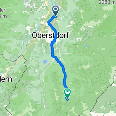 Rubi nach Trettachtal
- Distance
- 13.6 km
- Ascent
- 386 m
- Descent
- 73 m
- Location
- Oberstdorf, Bavaria, Germany
 Alpencross 2010 | Etappe 1
- Distance
- 59.3 km
- Ascent
- 1,978 m
- Descent
- 2,017 m
- Location
- Oberstdorf, Bavaria, Germany
 Runde zum großen Alpsee
- Distance
- 86.1 km
- Ascent
- 795 m
- Descent
- 864 m
- Location
- Oberstdorf, Bavaria, Germany
 Kornau - Söllereck - Riezlern - Breitach
- Distance
- 18.2 km
- Ascent
- 775 m
- Descent
- 778 m
- Location
- Oberstdorf, Bavaria, Germany
 Oberstdorf až Walserstraße, Mittelberg
- Distance
- 6.6 km
- Ascent
- 57 m
- Descent
- 240 m
- Location
- Oberstdorf, Bavaria, Germany
 06x Oberstdorf Rundweg über Spielmannsau
- Distance
- 34.6 km
- Ascent
- 899 m
- Descent
- 898 m
- Location
- Oberstdorf, Bavaria, Germany
 iller - Donautal 1.tag
- Distance
- 64.6 km
- Ascent
- 126 m
- Descent
- 224 m
- Location
- Oberstdorf, Bavaria, Germany
Open it in the app