
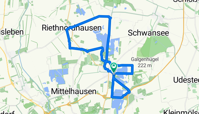
Radtour um die Erfurter Seen
A cycling route starting in Nöda, Free State of Thuringia, Germany.
Overview
About this route
Start am ParkplatzStrandbad Stotternheim
- -:--
- Duration
- 23.8 km
- Distance
- 45 m
- Ascent
- 47 m
- Descent
- ---
- Avg. speed
- ---
- Avg. speed

Route quality
Waytypes & surfaces along the route
Waytypes
Track
10.2 km
(43 %)
Quiet road
5.9 km
(25 %)
Surfaces
Paved
13.8 km
(58 %)
Unpaved
4.7 km
(20 %)
Asphalt
11.7 km
(49 %)
Gravel
2.4 km
(10 %)
Route highlights
Points of interest along the route
Point of interest after 20 km
Obstlehrpfad
Continue with Bikemap
Use, edit, or download this cycling route
You would like to ride Radtour um die Erfurter Seen or customize it for your own trip? Here is what you can do with this Bikemap route:
Free features
- Save this route as favorite or in collections
- Copy & plan your own version of this route
- Sync your route with Garmin or Wahoo
Premium features
Free trial for 3 days, or one-time payment. More about Bikemap Premium.
- Navigate this route on iOS & Android
- Export a GPX / KML file of this route
- Create your custom printout (try it for free)
- Download this route for offline navigation
Discover more Premium features.
Get Bikemap PremiumFrom our community
Other popular routes starting in Nöda
 Nöda Apolda
- Distance
- 48.3 km
- Ascent
- 351 m
- Descent
- 319 m
- Location
- Nöda, Free State of Thuringia, Germany
 Erfurt Gothaer Umland
- Distance
- 88.9 km
- Ascent
- 424 m
- Descent
- 424 m
- Location
- Nöda, Free State of Thuringia, Germany
 Erfurt - Straußfurt - Sömmerda - Erfurt - klein
- Distance
- 50.8 km
- Ascent
- 77 m
- Descent
- 76 m
- Location
- Nöda, Free State of Thuringia, Germany
 Nöda Bienstedt
- Distance
- 52.6 km
- Ascent
- 341 m
- Descent
- 344 m
- Location
- Nöda, Free State of Thuringia, Germany
 Nöda-Friemar-Craula-Bad Tennstedt-Nöda
- Distance
- 129.4 km
- Ascent
- 482 m
- Descent
- 485 m
- Location
- Nöda, Free State of Thuringia, Germany
 Nöda Söm Radweg
- Distance
- 32.1 km
- Ascent
- 115 m
- Descent
- 113 m
- Location
- Nöda, Free State of Thuringia, Germany
 Nöda - Ringelberg - Obernissa - Vieselbach - Nöda
- Distance
- 55.7 km
- Ascent
- 235 m
- Descent
- 233 m
- Location
- Nöda, Free State of Thuringia, Germany
 Erfurt Süd
- Distance
- 79.9 km
- Ascent
- 487 m
- Descent
- 487 m
- Location
- Nöda, Free State of Thuringia, Germany
Open it in the app