Teltschickturm - handschuh - heidelberg
A cycling route starting in Wilhelmsfeld, Baden-Württemberg, Germany.
Overview
About this route
- -:--
- Duration
- 11.3 km
- Distance
- 65 m
- Ascent
- 480 m
- Descent
- ---
- Avg. speed
- ---
- Avg. speed
Route quality
Waytypes & surfaces along the route
Waytypes
Track
6.2 km
(55 %)
Quiet road
2.9 km
(26 %)
Surfaces
Paved
7.4 km
(65 %)
Unpaved
3.8 km
(34 %)
Asphalt
7.3 km
(65 %)
Gravel
3.5 km
(31 %)
Continue with Bikemap
Use, edit, or download this cycling route
You would like to ride Teltschickturm - handschuh - heidelberg or customize it for your own trip? Here is what you can do with this Bikemap route:
Free features
- Save this route as favorite or in collections
- Copy & plan your own version of this route
- Sync your route with Garmin or Wahoo
Premium features
Free trial for 3 days, or one-time payment. More about Bikemap Premium.
- Navigate this route on iOS & Android
- Export a GPX / KML file of this route
- Create your custom printout (try it for free)
- Download this route for offline navigation
Discover more Premium features.
Get Bikemap PremiumFrom our community
Other popular routes starting in Wilhelmsfeld
- Weißer Stein - Mannheim
- Distance
- 17.9 km
- Ascent
- 89 m
- Descent
- 546 m
- Location
- Wilhelmsfeld, Baden-Württemberg, Germany
- Ziegelhausen, Heiligkreuzsteinach, Hirschhorn, Schönbrunn
- Distance
- 55.1 km
- Ascent
- 1,407 m
- Descent
- 1,408 m
- Location
- Wilhelmsfeld, Baden-Württemberg, Germany
- Bianx & Sam Extension
- Distance
- 21 km
- Ascent
- 429 m
- Descent
- 498 m
- Location
- Wilhelmsfeld, Baden-Württemberg, Germany
- Heidelberg Ostermontag
- Distance
- 39.5 km
- Ascent
- 1,189 m
- Descent
- 1,205 m
- Location
- Wilhelmsfeld, Baden-Württemberg, Germany
- Von Weinheim bis Heiligkreuzsteinach
- Distance
- 8.7 km
- Ascent
- 306 m
- Descent
- 339 m
- Location
- Wilhelmsfeld, Baden-Württemberg, Germany
- römerman
- Distance
- 34.2 km
- Ascent
- 626 m
- Descent
- 626 m
- Location
- Wilhelmsfeld, Baden-Württemberg, Germany
- Dirtsurf Wilhelmsfeld-Schriesheim
- Distance
- 9.7 km
- Ascent
- 56 m
- Descent
- 445 m
- Location
- Wilhelmsfeld, Baden-Württemberg, Germany
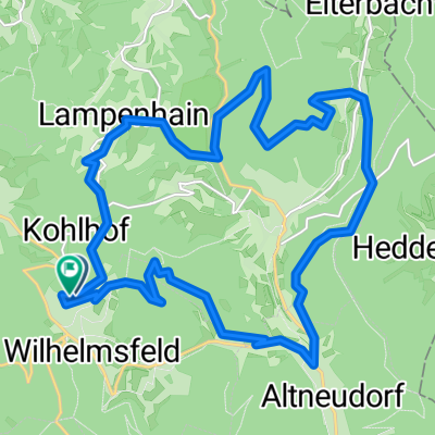
- Wilhelmsfed-Lampenhain-Heiligkreuz und zurück
- Distance
- 21.2 km
- Ascent
- 629 m
- Descent
- 632 m
- Location
- Wilhelmsfeld, Baden-Württemberg, Germany
Open it in the app