

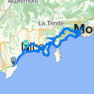
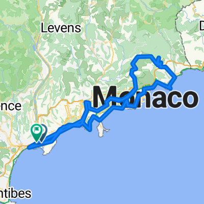
Itinéraire vers 1–3 Rue André Cane, Beaulieu-sur-Mer
A cycling route starting in Saint-Laurent-du-Var, Provence-Alpes-Côte d'Azur Region, France.
Overview
About this route
- 1 h 39 min
- Duration
- 17.2 km
- Distance
- 6 m
- Ascent
- 15 m
- Descent
- 10.4 km/h
- Avg. speed
- ---
- Max. altitude
Route quality
Waytypes & surfaces along the route
Waytypes
Cycleway
7 km
(41 %)
Pedestrian area
2.1 km
(12 %)
Surfaces
Paved
16.7 km
(97 %)
Asphalt
16.5 km
(96 %)
Concrete
0.2 km
(1 %)
Undefined
0.5 km
(3 %)
Continue with Bikemap
Use, edit, or download this cycling route
You would like to ride Itinéraire vers 1–3 Rue André Cane, Beaulieu-sur-Mer or customize it for your own trip? Here is what you can do with this Bikemap route:
Free features
- Save this route as favorite or in collections
- Copy & plan your own version of this route
- Sync your route with Garmin or Wahoo
Premium features
Free trial for 3 days, or one-time payment. More about Bikemap Premium.
- Navigate this route on iOS & Android
- Export a GPX / KML file of this route
- Create your custom printout (try it for free)
- Download this route for offline navigation
Discover more Premium features.
Get Bikemap PremiumFrom our community
Other popular routes starting in Saint-Laurent-du-Var
 Frankreich 845 km
- Distance
- 844 km
- Ascent
- 7,485 m
- Descent
- 7,364 m
- Location
- Saint-Laurent-du-Var, Provence-Alpes-Côte d'Azur Region, France
 Nizza-Manosque
- Distance
- 186 km
- Ascent
- 1,316 m
- Descent
- 997 m
- Location
- Saint-Laurent-du-Var, Provence-Alpes-Côte d'Azur Region, France
 Itinéraire vers 1–3 Rue André Cane, Beaulieu-sur-Mer
- Distance
- 17.2 km
- Ascent
- 6 m
- Descent
- 15 m
- Location
- Saint-Laurent-du-Var, Provence-Alpes-Côte d'Azur Region, France
 FRANCIA_141_2895
- Distance
- 138.2 km
- Ascent
- 2,823 m
- Descent
- 2,825 m
- Location
- Saint-Laurent-du-Var, Provence-Alpes-Côte d'Azur Region, France
 Southern French Alps 2004 stage 0
- Distance
- 37.6 km
- Ascent
- 540 m
- Descent
- 525 m
- Location
- Saint-Laurent-du-Var, Provence-Alpes-Côte d'Azur Region, France
 Tour France_ Nice - Nice ITT
- Distance
- 43.8 km
- Ascent
- 657 m
- Descent
- 634 m
- Location
- Saint-Laurent-du-Var, Provence-Alpes-Côte d'Azur Region, France
 FRANCIA_????_patrikfroment
- Distance
- 197.6 km
- Ascent
- 3,039 m
- Descent
- 3,022 m
- Location
- Saint-Laurent-du-Var, Provence-Alpes-Côte d'Azur Region, France
 De 18 Avenue du Docteur Émile Roux, Nice à 1 Calada Auguste Escoffier, Nice
- Distance
- 13.6 km
- Ascent
- 0 m
- Descent
- 10 m
- Location
- Saint-Laurent-du-Var, Provence-Alpes-Côte d'Azur Region, France
Open it in the app