
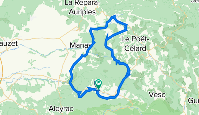
53k Dieulefit
A cycling route starting in Dieulefit, Auvergne-Rhône-Alpes, France.
Overview
About this route
- -:--
- Duration
- 52.3 km
- Distance
- 821 m
- Ascent
- 815 m
- Descent
- ---
- Avg. speed
- 626 m
- Max. altitude

Route quality
Waytypes & surfaces along the route
Waytypes
Road
34.2 km
(65 %)
Quiet road
8.9 km
(17 %)
Surfaces
Paved
16.1 km
(31 %)
Asphalt
15.6 km
(30 %)
Paved (undefined)
0.5 km
(<1 %)
Undefined
36.2 km
(69 %)
Continue with Bikemap
Use, edit, or download this cycling route
You would like to ride 53k Dieulefit or customize it for your own trip? Here is what you can do with this Bikemap route:
Free features
- Save this route as favorite or in collections
- Copy & plan your own version of this route
- Sync your route with Garmin or Wahoo
Premium features
Free trial for 3 days, or one-time payment. More about Bikemap Premium.
- Navigate this route on iOS & Android
- Export a GPX / KML file of this route
- Create your custom printout (try it for free)
- Download this route for offline navigation
Discover more Premium features.
Get Bikemap PremiumFrom our community
Other popular routes starting in Dieulefit
 Etape 4 Eté 2022
- Distance
- 48.8 km
- Ascent
- 743 m
- Descent
- 840 m
- Location
- Dieulefit, Auvergne-Rhône-Alpes, France
 La Paillette , Messy
- Distance
- 57.7 km
- Ascent
- 495 m
- Descent
- 1,050 m
- Location
- Dieulefit, Auvergne-Rhône-Alpes, France
 2016 Ride Day 102 - Vesc Circle to St-Nazaire-le-Désert
- Distance
- 52.5 km
- Ascent
- 1,048 m
- Descent
- 1,048 m
- Location
- Dieulefit, Auvergne-Rhône-Alpes, France
 2016 Ride Day 103 - Vesc Circle to Valence
- Distance
- 70.2 km
- Ascent
- 243 m
- Descent
- 670 m
- Location
- Dieulefit, Auvergne-Rhône-Alpes, France
 2016 Ride Day 99 - Vesc Circle
- Distance
- 40.1 km
- Ascent
- 782 m
- Descent
- 781 m
- Location
- Dieulefit, Auvergne-Rhône-Alpes, France
 tour autour st nazaire
- Distance
- 113.6 km
- Ascent
- 2,256 m
- Descent
- 2,256 m
- Location
- Dieulefit, Auvergne-Rhône-Alpes, France
 2016 Ride Day 101 - Vesc Circle to Col de la Chaudière
- Distance
- 76.9 km
- Ascent
- 1,318 m
- Descent
- 1,319 m
- Location
- Dieulefit, Auvergne-Rhône-Alpes, France
 2014 sainte jalle nord 109 km
- Distance
- 108.7 km
- Ascent
- 1,782 m
- Descent
- 1,803 m
- Location
- Dieulefit, Auvergne-Rhône-Alpes, France
Open it in the app