

Söllereck - Hörnlepass - Rohrmoos
A cycling route starting in Oberstdorf, Bavaria, Germany.
Overview
About this route
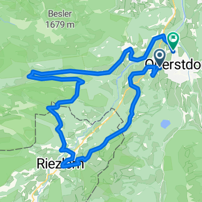
Von Oberstdorf fahren wir im Wald zum Freibergsee hinauf. Dann rechts zum Berghaus Hochleite. Dann geröllig bergauf zum Berghaus Söller (gutes Essen). Anschließend den Wanderweg hinab ins Kleinwalsertal. Vor dort über Schwende über den Hörnlepass auf die Engenkopfrunde. Kurz danach geht es hinab nach Rohrmoos und weiter talabwärts nach Tiefenbach. An der Breitach entlang nach Oberstsdorf zurück
- -:--
- Duration
- 38.7 km
- Distance
- 930 m
- Ascent
- 927 m
- Descent
- ---
- Avg. speed
- 1,416 m
- Avg. speed
Continue with Bikemap
Use, edit, or download this cycling route
You would like to ride Söllereck - Hörnlepass - Rohrmoos or customize it for your own trip? Here is what you can do with this Bikemap route:
Free features
- Save this route as favorite or in collections
- Copy & plan your own version of this route
- Sync your route with Garmin or Wahoo
Premium features
Free trial for 3 days, or one-time payment. More about Bikemap Premium.
- Navigate this route on iOS & Android
- Export a GPX / KML file of this route
- Create your custom printout (try it for free)
- Download this route for offline navigation
Discover more Premium features.
Get Bikemap PremiumFrom our community
Other popular routes starting in Oberstdorf
 Balderschwang Riedbergpass
- Distance
- 50.1 km
- Ascent
- 1,065 m
- Descent
- 1,065 m
- Location
- Oberstdorf, Bavaria, Germany
 7) Radtour Kleinwalsertal
- Distance
- 34.1 km
- Ascent
- 899 m
- Descent
- 902 m
- Location
- Oberstdorf, Bavaria, Germany
 Oberstdorf - Käseralpe
- Distance
- 22.8 km
- Ascent
- 631 m
- Descent
- 630 m
- Location
- Oberstdorf, Bavaria, Germany
 Illerradweg
- Distance
- 145.8 km
- Ascent
- 342 m
- Descent
- 676 m
- Location
- Oberstdorf, Bavaria, Germany
 Oberstdorf - Königsträßchen
- Distance
- 64.7 km
- Ascent
- 785 m
- Descent
- 785 m
- Location
- Oberstdorf, Bavaria, Germany
 MTB Oberstdorf - DAY_5 (6_2009) - Kanzelwand
- Distance
- 43.4 km
- Ascent
- 1,377 m
- Descent
- 1,377 m
- Location
- Oberstdorf, Bavaria, Germany
 Oberstdorf Marathon 2015 Mittelstrecke
- Distance
- 32.2 km
- Ascent
- 733 m
- Descent
- 735 m
- Location
- Oberstdorf, Bavaria, Germany
 Transalp Oberstdorf - Stilfserjoch - Laas
- Distance
- 289.9 km
- Ascent
- 7,211 m
- Descent
- 7,110 m
- Location
- Oberstdorf, Bavaria, Germany
Open it in the app