
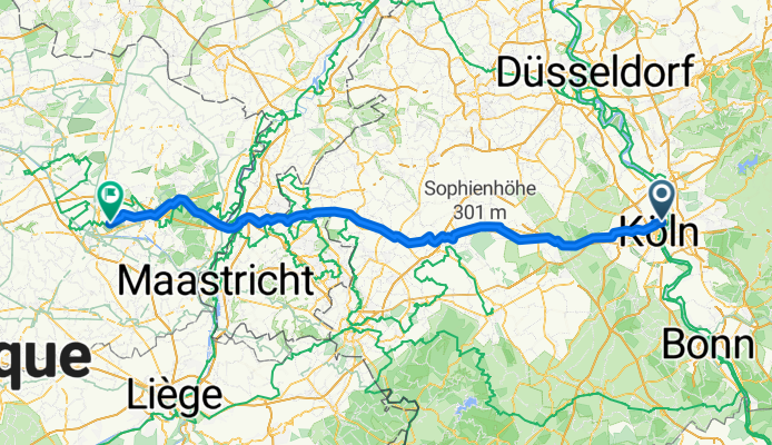
Amsterdamer Straße 89, Köln nach Bokrijklaan, Genk
A cycling route starting in Riehl, North Rhine-Westphalia, Germany.
Overview
About this route
- 7 h 56 min
- Duration
- 131.8 km
- Distance
- 555 m
- Ascent
- 558 m
- Descent
- 16.6 km/h
- Avg. speed
- ---
- Max. altitude
Continue with Bikemap
Use, edit, or download this cycling route
You would like to ride Amsterdamer Straße 89, Köln nach Bokrijklaan, Genk or customize it for your own trip? Here is what you can do with this Bikemap route:
Free features
- Save this route as favorite or in collections
- Copy & plan your own version of this route
- Split it into stages to create a multi-day tour
- Sync your route with Garmin or Wahoo
Premium features
Free trial for 3 days, or one-time payment. More about Bikemap Premium.
- Navigate this route on iOS & Android
- Export a GPX / KML file of this route
- Create your custom printout (try it for free)
- Download this route for offline navigation
Discover more Premium features.
Get Bikemap PremiumFrom our community
Other popular routes starting in Riehl
 Einkaufen und Sightseeing Köln
- Distance
- 14.9 km
- Ascent
- 3 m
- Descent
- 13 m
- Location
- Riehl, North Rhine-Westphalia, Germany
 131. Pulheimer Sonntagstour
- Distance
- 43.9 km
- Ascent
- 54 m
- Descent
- 53 m
- Location
- Riehl, North Rhine-Westphalia, Germany
 Leidener Straße 2-4, Köln to Delfter Straße 3, Köln
- Distance
- 27 km
- Ascent
- 116 m
- Descent
- 114 m
- Location
- Riehl, North Rhine-Westphalia, Germany
 Kleine Rennradrunde
- Distance
- 31.3 km
- Ascent
- 31 m
- Descent
- 31 m
- Location
- Riehl, North Rhine-Westphalia, Germany
 Köln - Bonn - Köln 2009
- Distance
- 80.1 km
- Ascent
- 355 m
- Descent
- 354 m
- Location
- Riehl, North Rhine-Westphalia, Germany
 Riehl Cycling
- Distance
- 27.5 km
- Ascent
- 58 m
- Descent
- 40 m
- Location
- Riehl, North Rhine-Westphalia, Germany
 Ein Teil des Grüngürtelsrundwegs in Köln
- Distance
- 29.6 km
- Ascent
- 90 m
- Descent
- 53 m
- Location
- Riehl, North Rhine-Westphalia, Germany
 Geländetour durch den Grüngürtel
- Distance
- 53.9 km
- Ascent
- 114 m
- Descent
- 114 m
- Location
- Riehl, North Rhine-Westphalia, Germany
Open it in the app