

Ennsradweg: Radstadt - Amstetten (2021)
Enns - Amstetten
A cycling route starting in Enns, Upper Austria, Austria.
Overview
About this route
Ennsradweg: Radstadt - Amstetten, Tag 5/5
Routensammlung Ennsradweg: Radstadt - Amstetten
Tag 4: Reichraming - Enns
- -:--
- Duration
- 53.1 km
- Distance
- 174 m
- Ascent
- 156 m
- Descent
- ---
- Avg. speed
- 360 m
- Max. altitude

Part of
Route quality
Waytypes & surfaces along the route
Waytypes
Cycleway
26.5 km
(50 %)
Quiet road
10.6 km
(20 %)
Surfaces
Paved
45.1 km
(85 %)
Asphalt
43.5 km
(82 %)
Paved (undefined)
1.6 km
(3 %)
Undefined
8 km
(15 %)
Route highlights
Points of interest along the route

Point of interest after 1.1 km
Basilika St. Laurenz

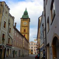
Point of interest after 2.3 km
Stadtturm Enns, Blickrichtung Süden
Drinking water after 27 km

Point of interest after 47.9 km
Stift Ardagger
Continue with Bikemap
Use, edit, or download this cycling route
You would like to ride Enns - Amstetten or customize it for your own trip? Here is what you can do with this Bikemap route:
Free features
- Save this route as favorite or in collections
- Copy & plan your own version of this route
- Sync your route with Garmin or Wahoo
Premium features
Free trial for 3 days, or one-time payment. More about Bikemap Premium.
- Navigate this route on iOS & Android
- Export a GPX / KML file of this route
- Create your custom printout (try it for free)
- Download this route for offline navigation
Discover more Premium features.
Get Bikemap PremiumFrom our community
Other popular routes starting in Enns
 03.06.2018
- Distance
- 8.7 km
- Ascent
- 46 m
- Descent
- 28 m
- Location
- Enns, Upper Austria, Austria
 Ruta otro lado del Danuvio_Mas allá
- Distance
- 47.6 km
- Ascent
- 488 m
- Descent
- 488 m
- Location
- Enns, Upper Austria, Austria
 26.05.2018
- Distance
- 9.6 km
- Ascent
- 24 m
- Descent
- 40 m
- Location
- Enns, Upper Austria, Austria
 Samstag
- Distance
- 8.7 km
- Ascent
- 116 m
- Descent
- 40 m
- Location
- Enns, Upper Austria, Austria
 Enns - Mostviertel - Donau
- Distance
- 82.8 km
- Ascent
- 561 m
- Descent
- 563 m
- Location
- Enns, Upper Austria, Austria
 Route to Steyr Ostufer
- Distance
- 26.5 km
- Ascent
- 159 m
- Descent
- 106 m
- Location
- Enns, Upper Austria, Austria
 Enns-Sk.Florian-Mas allá-Thann-Enns
- Distance
- 46.3 km
- Ascent
- 517 m
- Descent
- 519 m
- Location
- Enns, Upper Austria, Austria
 Route to Steyr - Westufer
- Distance
- 25.4 km
- Ascent
- 218 m
- Descent
- 165 m
- Location
- Enns, Upper Austria, Austria
Open it in the app