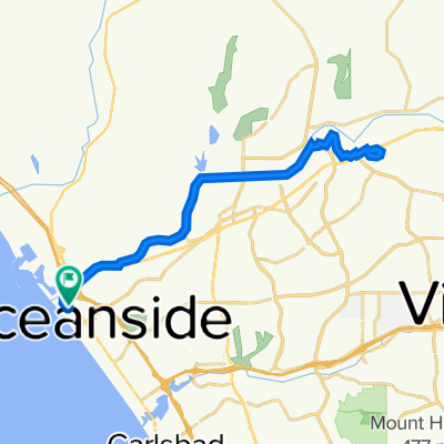
240 S Harbor Dr, Oceanside to San Luis Rey Bike Path, Oceanside
A cycling route starting in Oceanside, California, United States.
Overview
About this route
- 31 min
- Duration
- 12.2 km
- Distance
- 110 m
- Ascent
- 88 m
- Descent
- 23.4 km/h
- Avg. speed
- ---
- Max. altitude
Route quality
Waytypes & surfaces along the route
Waytypes
Cycleway
11.2 km
(92 %)
Access road
0.6 km
(5 %)
Surfaces
Paved
11.3 km
(93 %)
Paved (undefined)
7.7 km
(63 %)
Asphalt
3.4 km
(28 %)
Continue with Bikemap
Use, edit, or download this cycling route
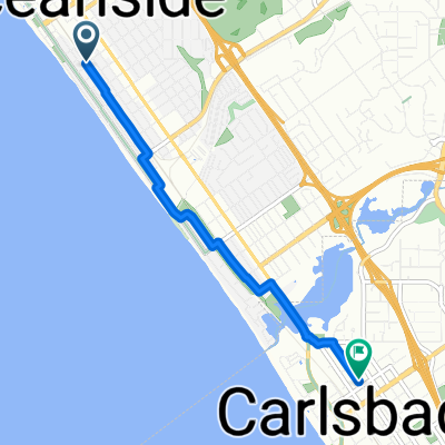
You would like to ride 240 S Harbor Dr, Oceanside to San Luis Rey Bike Path, Oceanside or customize it for your own trip? Here is what you can do with this Bikemap route:
Free features
- Save this route as favorite or in collections
- Copy & plan your own version of this route
- Sync your route with Garmin or Wahoo
Premium features
Free trial for 3 days, or one-time payment. More about Bikemap Premium.
- Navigate this route on iOS & Android
- Export a GPX / KML file of this route
- Create your custom printout (try it for free)
- Download this route for offline navigation
Discover more Premium features.
Get Bikemap PremiumFrom our community
Other popular routes starting in Oceanside
- Oceanside - San Diego
- Distance
- 64 km
- Ascent
- 268 m
- Descent
- 276 m
- Location
- Oceanside, California, United States
- John's Oside
- Distance
- 7.8 km
- Ascent
- 86 m
- Descent
- 70 m
- Location
- Oceanside, California, United States
- S Tremont St, Oceanside to I-5 S, San Diego
- Distance
- 66.7 km
- Ascent
- 415 m
- Descent
- 428 m
- Location
- Oceanside, California, United States
- Recovered Route
- Distance
- 13.6 km
- Ascent
- 0 m
- Descent
- 8 m
- Location
- Oceanside, California, United States
- 355–359 N Ditmar St, Oceanside to Second Ave, San Diego
- Distance
- 79.5 km
- Ascent
- 512 m
- Descent
- 509 m
- Location
- Oceanside, California, United States
- 321 S Tremont St, Oceanside to 311 S Tremont St, Oceanside
- Distance
- 26.1 km
- Ascent
- 3 m
- Descent
- 16 m
- Location
- Oceanside, California, United States
- Windward Way 688, Oceanside to Ocean Street 3200, Carlsbad
- Distance
- 7 km
- Ascent
- 43 m
- Descent
- 43 m
- Location
- Oceanside, California, United States
- Oceanside Pier to Mission Point
- Distance
- 66.4 km
- Ascent
- 268 m
- Descent
- 269 m
- Location
- Oceanside, California, United States
Open it in the app