

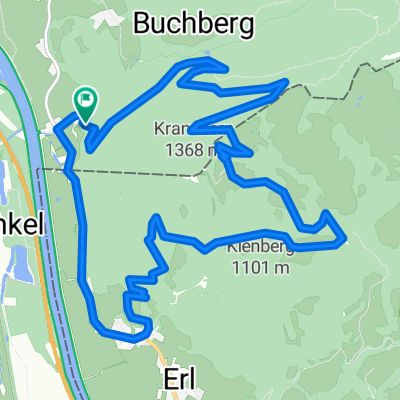
J10-Zankel-Prielau
A cycling route starting in Flintsbach, Bavaria, Germany.
Overview
About this route
- -:--
- Duration
- 95 km
- Distance
- 691 m
- Ascent
- 410 m
- Descent
- ---
- Avg. speed
- 778 m
- Max. altitude

Route quality
Waytypes & surfaces along the route
Waytypes
Quiet road
26.6 km
(28 %)
Path
19 km
(20 %)
Surfaces
Paved
60.8 km
(64 %)
Unpaved
9.5 km
(10 %)
Asphalt
59.8 km
(63 %)
Gravel
4.7 km
(5 %)
Route highlights
Points of interest along the route
Bike service after 0.3 km
Bike - Velo
Point of interest after 0.3 km
Commerce Bouffe
Bike service after 0.3 km
Bike-velo
Bike service after 0.3 km
Bike-velo
Bike service after 0.3 km
Bike-velo
Continue with Bikemap
Use, edit, or download this cycling route
You would like to ride J10-Zankel-Prielau or customize it for your own trip? Here is what you can do with this Bikemap route:
Free features
- Save this route as favorite or in collections
- Copy & plan your own version of this route
- Split it into stages to create a multi-day tour
- Sync your route with Garmin or Wahoo
Premium features
Free trial for 3 days, or one-time payment. More about Bikemap Premium.
- Navigate this route on iOS & Android
- Export a GPX / KML file of this route
- Create your custom printout (try it for free)
- Download this route for offline navigation
Discover more Premium features.
Get Bikemap PremiumFrom our community
Other popular routes starting in Flintsbach
 runde flinntsbach triathlon
- Distance
- 5.5 km
- Ascent
- 10 m
- Descent
- 8 m
- Location
- Flintsbach, Bavaria, Germany
 Von Flintsbach am Inn nach Wasserburg am Inn
- Distance
- 50.9 km
- Ascent
- 274 m
- Descent
- 257 m
- Location
- Flintsbach, Bavaria, Germany
 Von Flintsbach nach Wasserburg am Inn
- Distance
- 46.1 km
- Ascent
- 123 m
- Descent
- 149 m
- Location
- Flintsbach, Bavaria, Germany
 Bergseen
- Distance
- 107.1 km
- Ascent
- 1,349 m
- Descent
- 1,349 m
- Location
- Flintsbach, Bavaria, Germany
 Asten
Asten- Distance
- 13 km
- Ascent
- 734 m
- Descent
- 734 m
- Location
- Flintsbach, Bavaria, Germany
 Kranzhorntrail
- Distance
- 15.5 km
- Ascent
- 854 m
- Descent
- 854 m
- Location
- Flintsbach, Bavaria, Germany
 um Kranzhorn und Spitzstein nach Erl
- Distance
- 26.9 km
- Ascent
- 951 m
- Descent
- 951 m
- Location
- Flintsbach, Bavaria, Germany
 Sudelfeld und Ursprungpass
- Distance
- 72.5 km
- Ascent
- 1,639 m
- Descent
- 1,642 m
- Location
- Flintsbach, Bavaria, Germany
Open it in the app