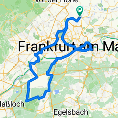
Bad Vilbel - Bonames - Weißkirchen - Ober Eschbach - Ober-Erlenbach - Nieder-Erlenbach - Bad Vilbel
A cycling route starting in Bad Vilbel, Hesse, Germany.
Overview
About this route
- -:--
- Duration
- 31.2 km
- Distance
- 130 m
- Ascent
- 124 m
- Descent
- ---
- Avg. speed
- 187 m
- Avg. speed
Route quality
Waytypes & surfaces along the route
Waytypes
Quiet road
10.9 km
(35 %)
Track
7.9 km
(25 %)
Surfaces
Paved
26.9 km
(86 %)
Unpaved
2.6 km
(8 %)
Asphalt
24.3 km
(78 %)
Gravel
2.4 km
(8 %)
Continue with Bikemap
Use, edit, or download this cycling route
You would like to ride Bad Vilbel - Bonames - Weißkirchen - Ober Eschbach - Ober-Erlenbach - Nieder-Erlenbach - Bad Vilbel or customize it for your own trip? Here is what you can do with this Bikemap route:
Free features
- Save this route as favorite or in collections
- Copy & plan your own version of this route
- Sync your route with Garmin or Wahoo
Premium features
Free trial for 3 days, or one-time payment. More about Bikemap Premium.
- Navigate this route on iOS & Android
- Export a GPX / KML file of this route
- Create your custom printout (try it for free)
- Download this route for offline navigation
Discover more Premium features.
Get Bikemap PremiumFrom our community
Other popular routes starting in Bad Vilbel
- Rundkurs ab Enkheim
- Distance
- 47.8 km
- Ascent
- 278 m
- Descent
- 285 m
- Location
- Bad Vilbel, Hesse, Germany
- RR Schnelle Feierabendrunde Frankfurt/Wetterau
- Distance
- 44 km
- Ascent
- 292 m
- Descent
- 276 m
- Location
- Bad Vilbel, Hesse, Germany
- Ronneburgrunde - ca. 550 Hm
- Distance
- 87.9 km
- Ascent
- 596 m
- Descent
- 564 m
- Location
- Bad Vilbel, Hesse, Germany
- Grüngürtel
- Distance
- 64.6 km
- Ascent
- 219 m
- Descent
- 212 m
- Location
- Bad Vilbel, Hesse, Germany
- Lange Radrunde durch Frankfurt am Main
- Distance
- 49.1 km
- Ascent
- 294 m
- Descent
- 288 m
- Location
- Bad Vilbel, Hesse, Germany
- RTF Niedererlenbach 114km Runde
- Distance
- 116 km
- Ascent
- 940 m
- Descent
- 928 m
- Location
- Bad Vilbel, Hesse, Germany
- Büdinger-Runde M (RB 091-0450)
- Distance
- 93.1 km
- Ascent
- 314 m
- Descent
- 313 m
- Location
- Bad Vilbel, Hesse, Germany
- Rundroute Bad Vilbel - Bad Homburg
- Distance
- 37.3 km
- Ascent
- 268 m
- Descent
- 269 m
- Location
- Bad Vilbel, Hesse, Germany